
DALLAS: FREEWAY PLANNING AND CONSTRUCTION
Posted March 9, 2026
Central Dallas, before-and-after government-funded highway construction, a process which displaced thousands during the 1950s-80s in the primarily Black and Latino neighborhoods surrounding Downtown. In the upper right, the animation shows the demographics of the area through which the highways were being built, roughly at the time of construction, 1950 (for the northern portion of the Central Expy) and 1960 (the others), scaled to the population in that tract.[1]
In a 1994 KERA documentary, "Big D Back When,” the narrator lists out some of these neighborhoods: "Little Mexico, the Thomas and Hall Area, Deep Ellum... these names create a ring of memories around Downtown that continue to inspire us, and inform us".[2] The documentary fails to note these neighborhoods have been reduced to a "ring of memories” because the space they once occupied is now a ring of concrete: the Central Expressway, and the Thornton, Stemmons, and Rodgers Freeways.
In addition to direct displacement, the highway loop acted as a wall around Downtown, reducing these “inner city” neighborhoods’ access to the CBD (by severing most local streets and pedestrian access), while simultaneously promoting suburban and regional automobile access—linking Downtown jobs to suburbs which enforced "whites only” segregation through a patchwork of public policy (exclusionary/racial zoning) and private practices (restrictive covenants, violence, etc.).[3] In this way, "just as the interstate system facilitated the development of white suburbs, it also drove the physical and economic destruction [and subsequent exclusion] of Black communities,” writes Deborah Archer.[4]
These impacts were by design. “The resulting disruption and pain these projects wrought was not, as some have argued, the result of some political accident or bureaucratic misstep on the part of otherwise earnest housing reformers,” writes N.D.B. Connolly. “Displacements were intentional. They represented, for growth-minded elites, successful attempts to contain black people and to subsidize regional economies with millions in federal spending.”[5]
Connolly’s description matches Dallas history almost exactly. Read on for more.
ADMIN NOTE: This caption is a section of my in progress PhD thesis, which is about different strategies for “Reconnecting Communities” divided by highways—so it’s a bit longer than usual posts. While this post isn’t about reconnecting communities—this focuses on history—it sets up the discussion (to come) about the different possible solutions. Also, some of the graphics/tables/figures are still WIPs.
Whose “Dallas of Tomorrow”? The Bartholomew Plan and the History of Inner Dallas, 1865 - 1990
PART 1: FORMATION (1865 – 1873)
Dallas’s modern growth begins with the arrival of the railroads in the 1870s. Development was fueled by the city's location at the first railroad crossroads in Texas, the intersection of the north-south Texas Central RR, which put Dallas on a line from Galveston and Houston up to St. Louis and on to Chicago; and the east-west Texas & Pacific RR, which connected the east coast to the maturing “frontier” towns of west, as the Indian genocide was entering its final stages. In this period immediately after the Civil War, the city quickly became a major freight, passenger, logistics, and financial hub for the region, a role which would only continue to expand.[6]
Much like other towns and cities in Texas, after Emancipation many recently freed slaves in the area had migrated to Dallas to escape sharecropping servitude and in search of better work opportunities in the early days of urban industrialization.[7] Largely prevented from living in existing neighborhoods due to official segregation, these communities built “Freedman’s Towns” on the outskirts of urban areas across the south, in this case the North Dallas Freedman’s Town (and the Tenth Street Freedman’s Town in the then-independent town of Oak Cliff) located just outside the city limits at the time.
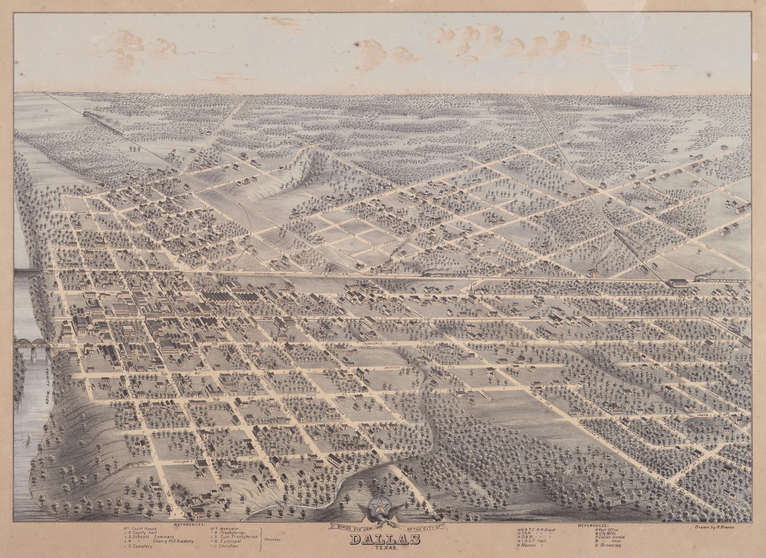
Figure 1: Birdseye illustration of Dallas, made 1872. Downtown is on the left. The area that would become the North Dallas Freedman’s town is on the upper right, while Deep Ellum would form around the railroad intersection on the right. (Source: Wikimedia Commons)
With the arrival of the Texas Central track, whose north-south arc cut through the relatively undeveloped east side of town before passing close to the nascent North Dallas Freedman's Town (seen on the right in Figure 1 above), the growing Black population spread south and formed additional neighborhoods along the right of way, filling in the eastern extensions of Elm, Main, and Commerce Streets that had been built to meet the new tracks.[8]
Unlike many other cities, especially older ones, where railroad tracks often acted as barriers between existing racial areas,[9] because the Central track had been built through a relatively undeveloped area (over a mile east of the existing built up area centered at Main/Market Streets) and before the city's racial lines had crystalized, it acted less as a barrier and more as a catalyst for the neighborhoods in its vicinity, Black and white. [10]
After the 1870s, spreading south along the tracks from the existing North Dallas Freedman's town, Black arrivals built a new neighborhood around the intersection of the Central and Pacific tracks, called "Deep Ellum,” (a phonetic spelling of "Deep Elm") referring to its position far down the extension of Elm Street. Another neighborhood, Stringtown, formed along the Central tracks themselves, connecting between Deep Ellum and Freedman's Town on a linear commercial and residential corridor (Figure 2). The railroads provided steady employment, and the constant stream of crowds—passengers, commuters, workers, etc. of all races—made Deep Ellum in particular a commercial and entertainment center. Dallas historian AC Green notes, "Dallas became a mecca for formerly enslaved,” and by 1900 the city's population was roughly 20% Black.[11]
Figure 2: Map from “Deep Ellum Blues,” southernspaces.org
PART 2: GROWTH (1873 – 1929)
By the turn of the 20th century, after the definitive failure of Reconstruction, the formal institution of Jim Crow segregation with the 1896 Plessy v. Ferguson ruling, and Dallas’ continued growth as a transport and financial hub, Deep Ellum had emerged as a sort of parallel, self-sufficient Black CBD, down Elm St. from "whites only” Downtown further west. Even after the city's main passenger terminal was moved from the intersection of the Central and Pacific tracks in the heart of Deep Ellum to its current location just west of Downtown in 1916, the area remained a Black residential and commercial center, anchored by hundreds of Black-owned businesses and frequented by multi-racial patrons from across the city.[12]
"The 1925 business directory [for Deep Ellum] lists everything from landscapers, doctors, cafes, real estate agencies, tailors, dance schools,” writes Collin Yarbrough in Paved A Way: Infrastructure, Policy and Racism in an American City. "The music and entertainment in the area allowed for the development of Black cultural experiences drawing strong crowds week in and week out.”[13] With Deep Ellum as the commercial core, segregation contained much of Dallas’ early population to the areas immediately northeast (Freedman's Town and Stringtown) and southeast (the residential portion of Deep Ellum) of Downtown. By this time, the old Freedman’s Town had become home to Dallas’ wealthiest Black residents, centered on the intersections of Thomas/Hall (Figure 3) and State/Hall, as the redlining comments put it: “Thomas and State streets best negro streets.”[14] During this time, the area also became known as the “Short North,” or simply “Thomas and Hall.”[15]

Figure 4: The intersection of Thomas/Hall in the North Dallas Freedman’s town was the commercial core of the neighborhood (Source: Dallas Genealogy Society)
Since the early days of the railroad, Dallas’ all white leadership in City Hall and in powerful Downtown business and real estate associations had sought to contain the growth of what newspapers at the time sometimes called the "Black Belt” that had formed around the eastern end of Downtown. This later grew to include Little Mexico (today's "Uptown"), to the north of Downtown and west of Freedman's Town, initially a Jewish area which had become home to thousands of Mexican immigrants after the Mexican Revolution in 1910-21. Like Freedman's Town, Little Mexico became a self-sufficient community with dozens of locally-owned businesses, including the El Fenix restaurant in 1918, still in business today on McKinney.[16] (More on this area to come).
While recognizing the necessity of (underpaid) Black and brown labor for the city's continued growth, as in other cities, Dallas leadership nonetheless sought to contain these neighborhood's expansion to ensure the population did not spread into areas designated whites-only.[17] Initially reliant on the legal framework of Jim Crow to police these boundaries, as well as the constant threat of racial violence from nothing less than the largest chapter of the Klu Klux Klan in the country (KKK No. 66, which had many members in City Hall), in the period leading up to WW2 unprecedented growth and new social forces would ultimately encourage leaders to seek new means of upholding racial hierarchy which would be more permanent than vigilante violence.[18]
Between 1900-1940, Dallas population grew 7x, one of the fastest growing in the country, including tens of thousands more Black migrants moving from the countryside as part of the Great Migration (which, while often portrayed as solely a movement from the rural south to northern cities, many larger southern cities such as Miami, Atlanta, and Dallas were also destinations for those seeking economic opportunity and reprieve from worsening rural Jim Crow).[19] Overcrowding in existing neighborhoods led new arrivals to increasingly seek accommodation in previously "whites only” areas, especially the neighborhood of South Dallas immediately adjacent to Deep Ellum, tentatively extending the "Black Belt” southwards (Figure 4).

Figure 4: This map [WIP] shows the percentage of Black residents in census tracts in central Dallas from the 1940 census, revealing the “Black Belt” around Downtown. (Source: 1940 Census, Social Explorer)
PART 3: VIOLENCE AND CONTAINMENT (1918 – 1943)
Partially facilitated by the 1917 Supreme Court case Buchanan v. Warley, which outlawed racial zoning ordinances such as the one Dallas had adopted (though other means of segregation, such as widespread restrictive covenants, remained in force), Black movement into South Dallas was initially met with racial terror from the KKK, with dynamite attacks and arson greeting newcomers throughout the 20s[20] (a period referred to nationally as the "nadir of American race relations” given similar developments in cities around the nation).[21] “The expansion of blacks into white areas in Oak Cliff, North Dallas, and South Dallas had helped give birth to the powerful Klu Klux Klan in the city during the 1920s,” Fairbanks writes.[22] The beginning of the Depression would only exacerbate these issues, with Klan membership continuing to grow in the area (at its peak, a staggering one out of every three eligible men in Dallas was a member of KKK No. 66)(Figure 4).[23]
By the late 30s as the city began to economically recover, prominent business leaders sought to shed Dallas's image as a place of racial violence and Klan lawlessness, as well as to address the haphazard pattern of growth they believed had contributed to it.[24] In 1937, RL Thornton, a Dallas banker and city booster, formed the Dallas Citizens Council (DCC), an invite-only “civic institution” consisting of the heads of large local businesses—an organization which from the onset held significant sway over City Hall. Throughout the 20th century, the DCC would have an outsized role in Dallas politics, selecting candidates for municipal office and constantly advancing an aggressive “pro-growth and pro-business” agenda.[25]
Decrying the Klan for its disorderly conduct—but not disagreeing with its goal of white supremacy—the Dallas Morning News (headed by leading DCC member George Dealey) wrote: “White supremacy is not imperiled. Vice is not rampant. The constituted agencies of government are still regnant. And if freedom is endangered, it is by the redivivus [sic] of the mob spirit in the disguised garb of the Klu Klux Klan.”[26] The DCC, made of Dallas’ wealthiest men and most prolific boosters, disapproved of the KKK not for its racism (on that they agreed, white supremacy must not be imperiled), but for what they perceived as the "mob" of mostly lower- and middle-class men which constituted the KKK’s membership and whose street violence was bad for attracting investment to the city.
In his landmark 1987 history of Dallas, “The Accommodation: The Politics of Race in an American City,” journalist Jim Schutze writes, “The true leadership of the city, which had been honing its oligarchical style since the 1930s, had never condoned bombing and lynching… the oligarchy of land developers who were just then consolidating their control over Dallas had lavish dreams for the future that could be spoiled by racial war.”[27]
Instead of mob violence, the DCC preferred a more capital-intensive, growth-oriented, and permanent approach: city planning. “One of the DCC’s earliest goals was the creation of a new master plan for the city of Dallas,” writes the Texas State Historical Association (TSHA) in its "Handbook of Texas." On the advisement of the DCC, “in 1943 the Dallas City Council commissioned Harland Bartholomew to produce a new plan for Greater Dallas, which closely reflected the organization’s vision.”[28]
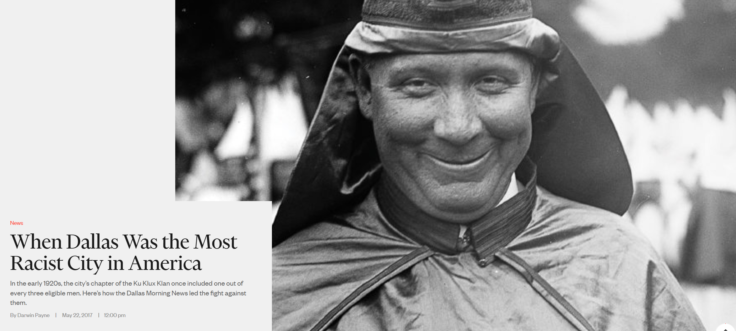
Figure 5: "When Dallas Was the Most Racist City in America” (Source: D Magazine)
PART 4: JIM CROW BY OTHER MEANS (1943 – 1956)
For the DCC, Bartholomew was a logical choice: a civil engineer by training, Bartholomew himself was a founding member of the American City Planning Institute (a predecessor of today's APA) and had personally done much to define the planning profession, serving as the first full time public-sector city planner in the US.[29] He was also a well-known advocate of using government to enforce racial segregation through land-use, a goal which he had made explicit in his prior city plans. Rothstein writes of Bartholomew’s 1911 city plan for St. Louis:
“According to Bartholomew, an important goal of St. Louis zoning was to prevent movement into ‘finer residential districts… by colored people.’ He noted that without a previous zoning law, such neighborhoods had become ‘run down’: ‘where values have depreciated, homes are either vacant or occupied by colored people.’ The survey Bartholomew supervised… attempted to estimate where African Americans might ‘encroach’ so the commission could respond with restrictions to control their spread.”[30] Dallas leaders hoped such restrictions would prevent another situation like that of South Dallas, and increasingly the adjacent Fair Park area, where a formerly white neighborhood had transitioned to predominantly Black (with the accompanying violence that had ensued).[31]
After Buchanan v. Warley had outlawed racial zoning in 1917, Bartholomew became an expert in evading such federal restrictions through more oblique mentions of racial exclusion[32] (e.g. in the Dallas plan using dog-whistle terms such as “neighborliness” to analyze residential areas), reliance on private practices such as restrictive covenants, as well as the widespread adoption of single-family zoning and encouragement automobile-based residential growth—known proxies for racially exclusionary zoning.[33]
By the time the DCC (and their ally in City Hall, Woodall Rogers) had hired Bartholomew & Associates in 1943 to execute their “vision,” the firm had created plans for over 20 cities around the country. Bartholomew himself had served as the chair of the planning committee on President Hoover’s 1931 conference on homeownership, which ultimately recommended that “appropriate” measures for the construction of new subdivisions included racial exclusion, a policy which under the next administration would form part of the basis for federal redlining.[34]
Much like other post-Buchanan plans the firm made, the language of the 1943 plan for Dallas (titled: "Your Dallas of Tomorrow: A Master Plan for Greater Dallas" [Figure 6]) was not as explicit in its segregationist intent as the St. Louis plan, but it contained the same general principles of inner-city containment and suburban exclusionary zoning which had been successful in other cities in creating segregationist outcomes—especially as the Great Migration had continued, and Black populations continued to rise in urban cores around the country.[35] Simultaneously, federal redlining, coming into force as part of the New Deal seven years prior, had severely restricted Black residents’ access to residential mortgages (and many other financial services), acting as another containment measure. Redlining, in combination with the widespread adoption of single-family zoning in new housing developments, would all but reconstitute the racial zoning that had been outlawed under Buchanan.

Figure 5: Harland Bartholomew, 1950 (Source: Wikipedia)
PART 5: MOBILITY FOR WHOM?
Even as the plan laid the groundwork for further suburban growth (and subsequent white flight) through the promotion of new, automobile-based and racially exclusionary subdivisions, "Bartholomew and his team were particularly concerned with the economic and social decline of the urban core of the city due to that suburban growth. In their reports they proposed an upgraded street plan with extensions and widenings to improve [automobile] traffic flow from all parts of Dallas to Downtown,” writes the Handbook of Texas. The plan made comparatively few provisions for public transit, which in cities across the country still-remained the primary mode of travel many middle- and most work-class travelers.[36] The 1943 plan, regional in scope, treated transit as “local” matter, largely the purview of the independent operators.
On highways, Bartholomew was more specific (Figure 7). The plan recommended an expressway network which, if enacted, would entirely encircle the commercial core in concrete, cutting through the surrounding neighborhoods and disconnecting local streets. Radiating from the inner loop were more highways, also cutting through the surrounding inner-city (including through the heart of the North Dallas Freedman’s Town at Thomas and Hall), connecting Downtown to the growing whites-only suburbs on the periphery, while also opening new land for further growth.
“Bartholomew designed the major street plan in part to protect the central business district against decline by making it more accessible,” writes Fairbanks in “For the City as a Whole: Planning, Politics, and the Public Interest in Dallas, 1900-1965.”[37] This accessibility, however, was explicitly for automobiles, in an era even more so than today, where “car ownership and lack thereof mark[ed] extant divisions of class, gender, citizenship, ability, and race.”[38] These highways would provide automobile accessibility between the growing suburbs and the core; while South Dallas, Deep Ellum—whose populations largely did not own cars—would be left facing trenches and walls of concrete.
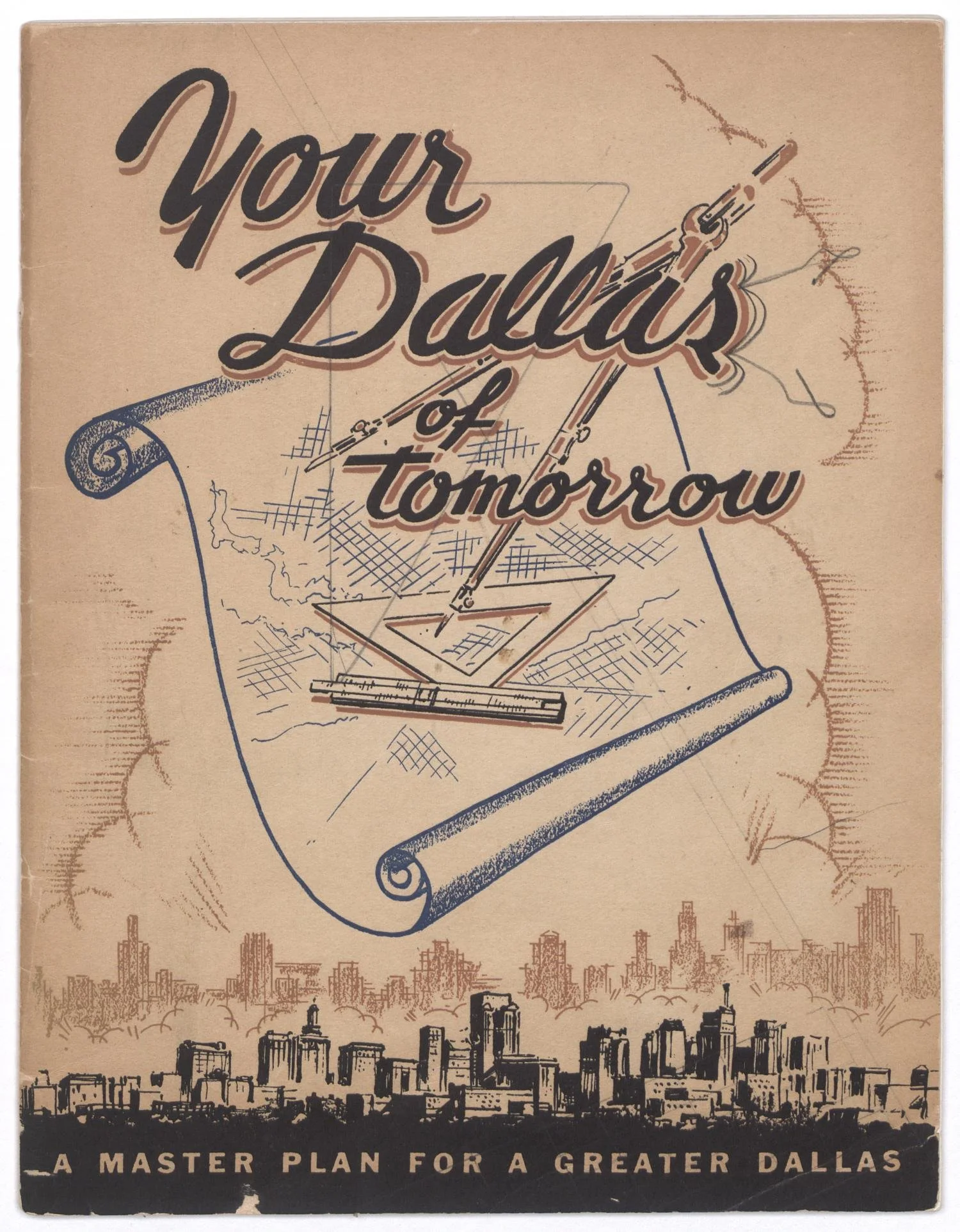
Figure 6: “Your Dallas of Tomorrow” cover page (Source: UNT Libraries)
Bartholomew’s road plan reflects the competing aims of the DCC: to reap profits from racially-restricted suburban real estate growth, while also facilitating “the development of a compact and stable business district, wherein high property values can be maintained over a long time.”[39] For balancing these aims, the plan relied on an assumption of the near limitless capacity of the automobile to bring the decentralized masses of new suburban residents to the urban core and back out again every day without issue—ignoring the fact that similar designs in New York and Los Angeles at the time had immediately resulted in worsened congestion, polluted air, and daily traffic jams that had increased, and not improved, travel times to Downtown.[40] This techno-optimism around the widespread adoption of automobiles was shared by the planning establishment,[41] encouraged by the maturing post-war “military-industrial complex,” which had deep financial interest in promoting automobile and fossil fuel adoption.[42] While recognizing the necessity of transit to “combat excessive congestion” and claiming to decry the city’s “decentralized tendency,”[43] the plan nonetheless called for entirely overhauling Downtown for the purpose of maximizing suburban and regional automobile access.
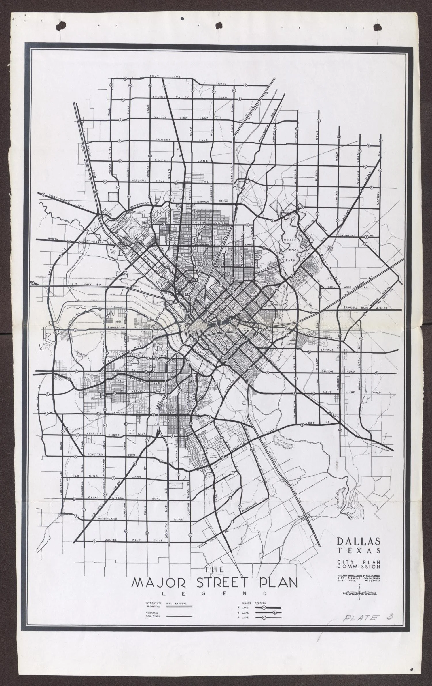
Figure 7: Bartholomew Street and Highway Plan (Source: UNT Libraries)
PART 6: SEGREGATION BY DESIGN - FORTRESS DOWNTOWN AND CITADEL SUBURBIA
For the members of the DCC, who between them owned most of the commercial property Downtown, the continued viability of the core as the center of economic activity was paramount. The growing “Black belt” around Downtown, described uniformly as “blighted areas” in the report, was perceived to threaten those property values—a perception which had been federally formalized through redlining in the 1934 National Housing Act, in which adjacency to non-white areas would rank an area lower in investment “security” (Figure 9). The Federal Housing Administration, established by the 1934 Act, issued its “Underwriting Manual and Valuation Procedure,” in which a prime factor in valuation was to “determine whether or not incompatible racial and social groups are present.”
“The manual also recognized the power of physical barriers in maintaining racial segregation and the value of white-owned property,” Archer writes. “In a section titled ‘Protection from Adverse Influences.’ It counseled that ‘naturally or artificially established barriers will prove effective in protecting a neighborhood and locations within it from adverse influences. Usually, protection from adverse influences afforded by these means includes prevention of the infiltration of business and industrial uses, lower class occupancy, and inharmonious racial groups.’ The manual highlighted how the presence of highways and roadways could be particularly useful in this assessment, suggesting that ‘a high speed traffic artery or a wide street parkway may prevent the expansion of inharmonious uses to the location on the opposite side of the street.’” By surrounding the core in wide roadways, Downtown property values would be protected from the surrounding “blight.” Archer writes of planners nationally, “highway engineers came to speak of ‘killing two birds with one stone’: they could improve traffic conditions while simultaneously removing [and containing] Black communities.”[44]
Complementing the highways, to further protect downtown and boost property values, the Bartholomew plan also advocated for the “redevelopment and revitalization”—urban renewal—of many close-in neighborhoods, including the Black residential section south of Deep Ellum, “to combat blight just outside the CBD.”[45] These plans included the development of a new “Civic Center” with a large city hall and convention center that would create another buffer between Downtown and surrounding areas. Archer writes, “although race neutral on the surface, urban renewal was infused with racial thinking. It was no secret that ‘blighted neighborhoods’ and ‘slums’ were euphemisms for Black neighborhoods—especially not to residents of such neighborhoods.”
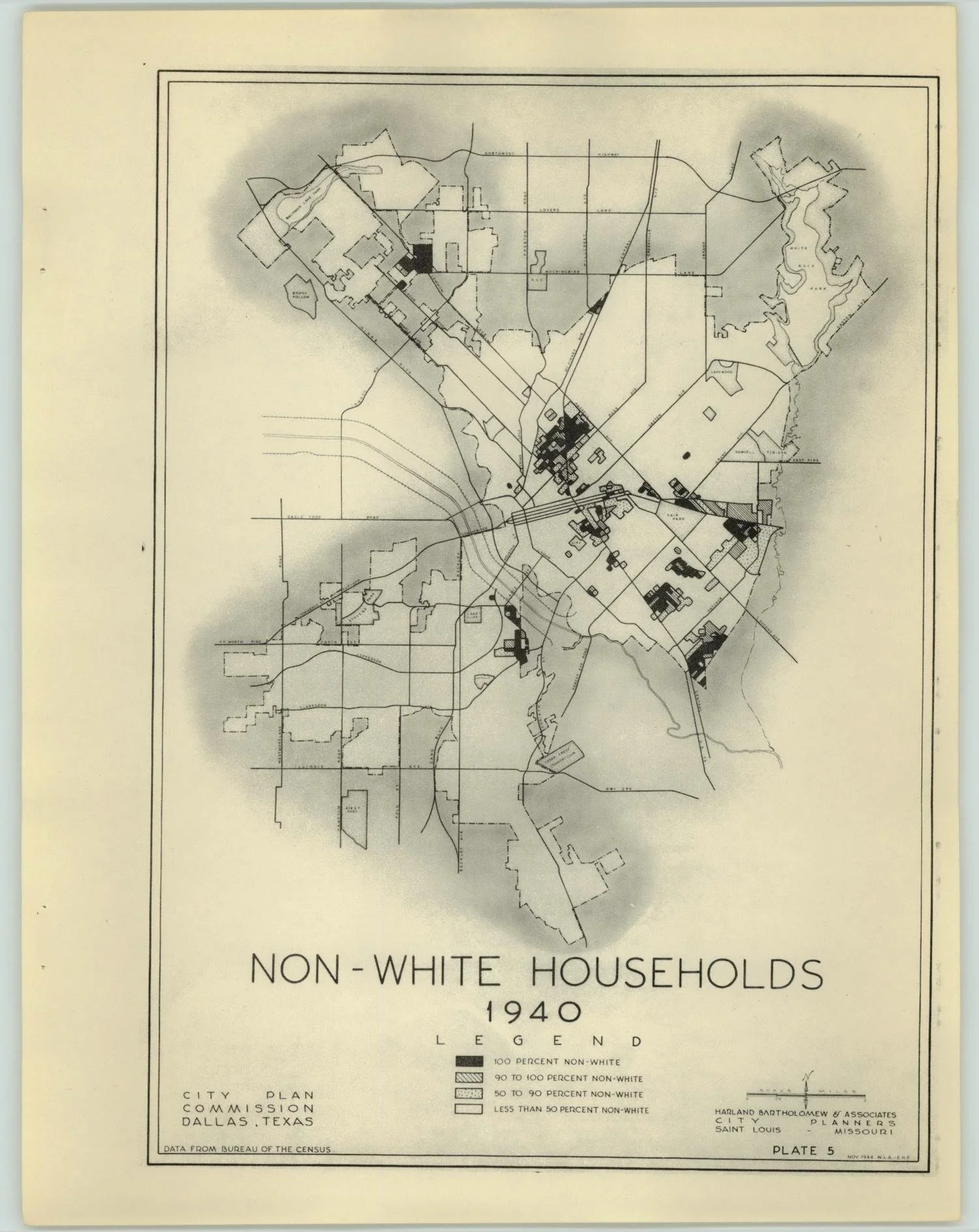
Figure 8: Bartholomew Plan “Non-white Households.” In earlier plans, Bartholomew explicitly states a goal “to prevent movement into ‘finer residential districts… by colored people.” (Source: UNT Libraries)
A popular phrase used by people and organizations [and famously James Baldwin] protesting the displacement was ‘urban renewal means negro removal.’”[46] In place of housing, the “revitalization” plan would see much of the built fabric of the Downtown core replaced with office towers and parking.
The economic logic of redlining meant that land-uses such as surface parking lots became seen as safe investments that could raise property values (both residential and commercial), while low-income and rental housing became active liabilities (especially adjacent to Downtown areas). Because of this, in addition to the highways themselves, “many cities saw parking lots as the replacements for the former sites of dense urban neighborhoods.”[47] Schutze notes that DCC member Joseph Ross had said that the “slums could be cleaned up and the land used for more positive and productive purposes (he suggested parking lots, to improve the value of Downtown property).”[48] Along with the new highways, the parking that took the place of Downtown and “inner city” housing would form a complementary element of the new Downtown automobile-based and suburban-focused superstructure, provide storage for commuters’ cars conveniently close to the CBD.
Even before the war, the economics of redlining had also incentivized increasing white flight, as white homebuyers sought safer investments outside the core and the red-lined inner city neighborhoods, away from non-whites who might harm home values, and in new subdivisions protected in space by the need for an automobile to access—and, of course, racially restrictive covenants. This tendency had accelerated the transition of South Dallas and the adjacent area around Fair Park to almost entirely Black over the ensuing decades.
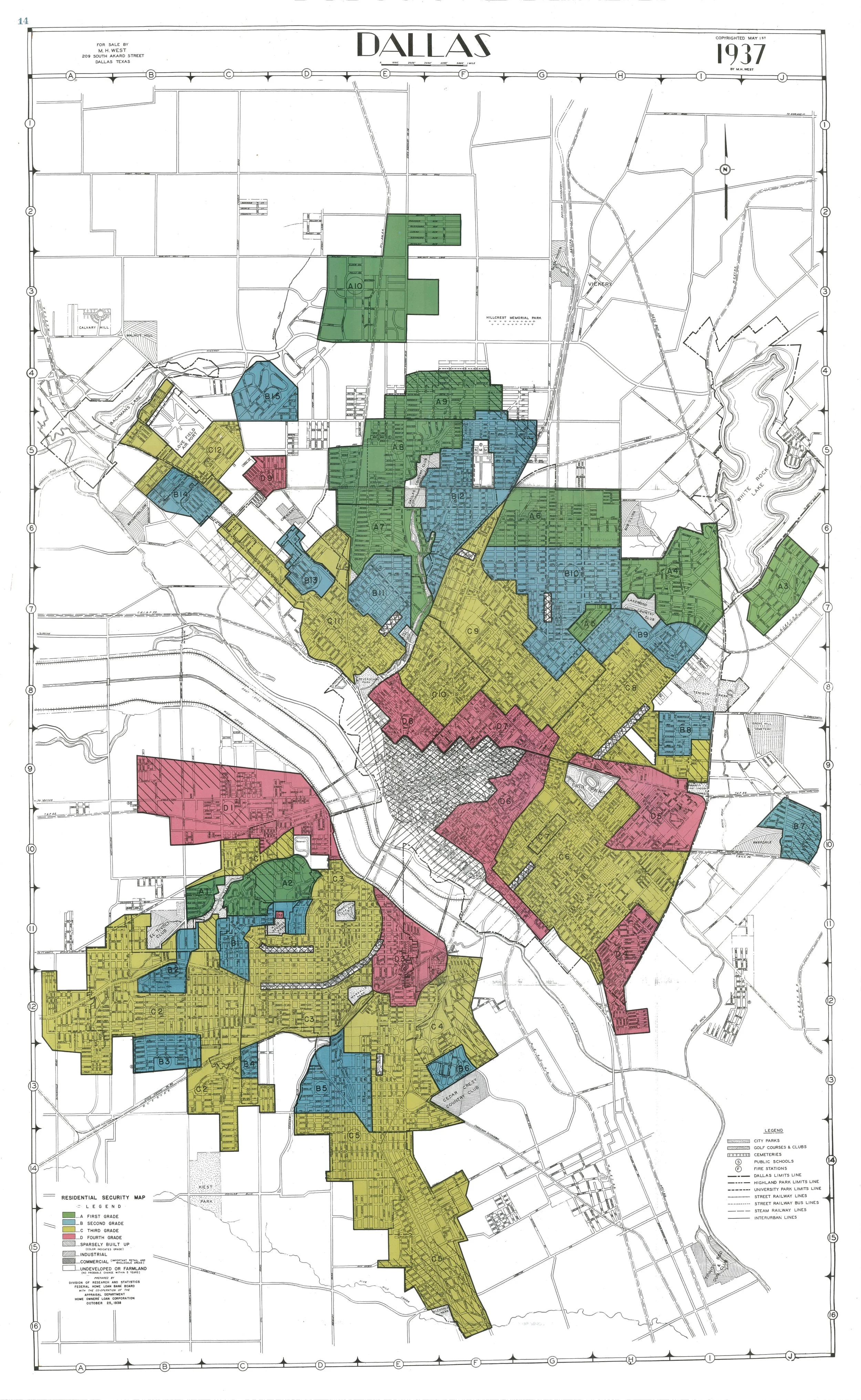
Figure 9: Dallas HOLC Redlining Map (Source: Mapping Inequality)
DCC leaders blamed declining event attendance at Fair Park venues on the surrounding area having become largely Black, and they hoped to avoid a similar a similar fate for Downtown. Shutz writes, “one published city report said brazenly that attendance at the fair had declined in recent years because fairgoers objected to being exposed to a ‘certain element’ on their way into Fair Park.”[49] In a focus group with white fairgoers, after expressing discomfort at the neighborhood—“You don’t reel safe around fair park,” said one focus group member—“the panel was asked: ‘If all the land around Fair Park were bought up and turned into a paved, lighted, and fenced parking lot, would that solve the problem?’ The Dallas citizens ‘answered with a resounding ‘Yes,’ confirming the City of Dallas’ plans.’”[50]
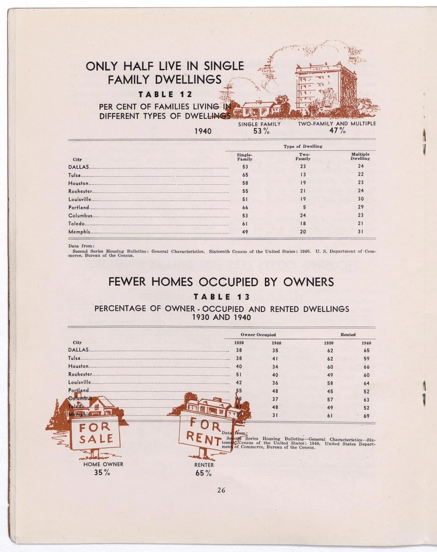
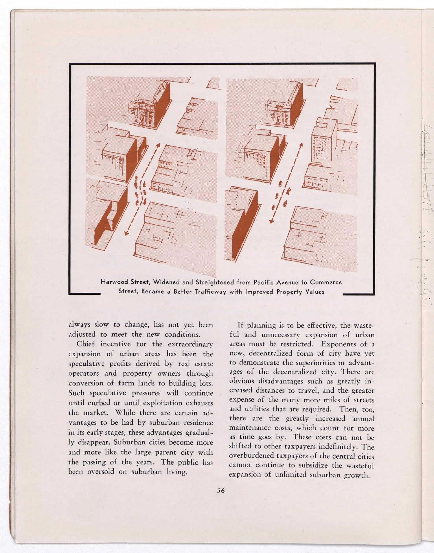
Figure 10: Despite decrying “decentralization” and accurately predicting the financial trouble it could cause, according to Bartholomew’s plan, the core would be redesigned to promote automobile accessibility (Source, UNT Libraries)
Figure 11: The plan also highlighted that “only” half of residents lived in single family homes, aiming to boost that number to ensure “residential stability.” (Source: UNT Libraries)
PART 7: EARLY IMPLEMENTATION (1945 – 1956)
The Bartholomew plan was approved by voters in a 1945 referendum, which created a $40 million (nearly $720m today) bond package to fund its implementation. While this sum did not end up being nearly enough to realize the entire plan in the immediate postwar years, construction of the Central Expressway over the old Central Track right of way was prioritized, seen at the start of the animation cutting through Freedman’s Town to connect the northern suburbs to Downtown.
While the idea to replace the northern portion of the Central Track with a roadway predates the Bartholomew, earlier proposals such as the one in the 1911 Kessler plan referred to redesigned ROW as a park-like “boulevard,” which would not be grade-separated and would function more like a traditional street.[51] Even before the construction of a railroad bypass in 1918 that had significantly reduced the number of trains on the Central Track, the right of way—which, as can been seen in the animation (and Figure 10), was quite narrow—had largely already been turned into a street (Central Avenue) with the occasional street-running freight train disrupting local traffic. Because of this, unlike wider railroad rights of way that acted as barriers, the Central Track/Avenue had instead acted as the central commercial drag of Stringtown (and the “Black Belt” as a whole), and the primary connection between the North Dallas Freedman’s Town and Deep Ellum (Figure 12).[52]
By the start of construction in 1947, the boulevard plans had morphed into the much wider Central Expressway. The highway was cut down the spine of the Black Belt on Central Ave, demolishing hundreds of homes, apartment buildings, churches, and dozens of businesses on either side. The highways cut through the heart of Freedman’s Town at Thomas and Hall, eliminating the node of Black prosperity that had anchored the neighborhood. The expressway divided one of the only high schools for Black students (in the pre-Brown v. Board era) from the residential portion of the neighborhood, making the journey to school significantly longer and more treacherous.[53] It had also cut through a corner of the 150-year old Freedman’s Cemetery. Interviews with residents “suggest headstones and other grave materials were mixed in with the construction fill.”
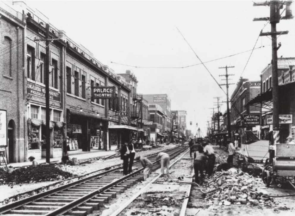
Figure 12: Stringtown, centered on the Central Track ROW, formed a linear commercial and residential corridor that connected Deep Ellum with the North Dallas Freedman’s Town. (Source: Flashback Dallas)
When the highway was completed in 1953 it had cut Freedman’s Town in half, wiped most of the linear neighborhood of Stringtown off the map, and left Deep Ellum inundated with regional traffic heading Downtown (Elm Street itself was made one way, “in effect, traffic was forced west toward Downtown and away from Deep Ellum”[54]). “The part that disappeared from Deep Ellum was the culture of the Central [Track], which was where all the Black businesses were located.” says Dallas historian Alan Govenar to Yarbrough, “And that was intentional.”[55] Many of the displaced relocated to South Dallas and Oak Cliff, further encouraging racial violence and subsequent white flight from those areas.[56]
Apart from the Central Expressway, complete implementation of the Bartholomew Plan had stalled by the early 50s due to a lack of adequate funding. The city’s extreme population growth in the immediate post-war period—partially fueled by the growth of the oil industry, by the end of 1946 Dallas already had 75,000 more people than the master plan had anticipated—had immediately exhausted the funds from the 1945 bond measure and strained the city’s finances. Fairbanks writes, “although the city’s tax base increased substantially, the population influx caused greater demand for high-priced infrastructure development, especially water, and for an increase in city police and fire protection,”[57] leading to fiscal crisis by 1952.
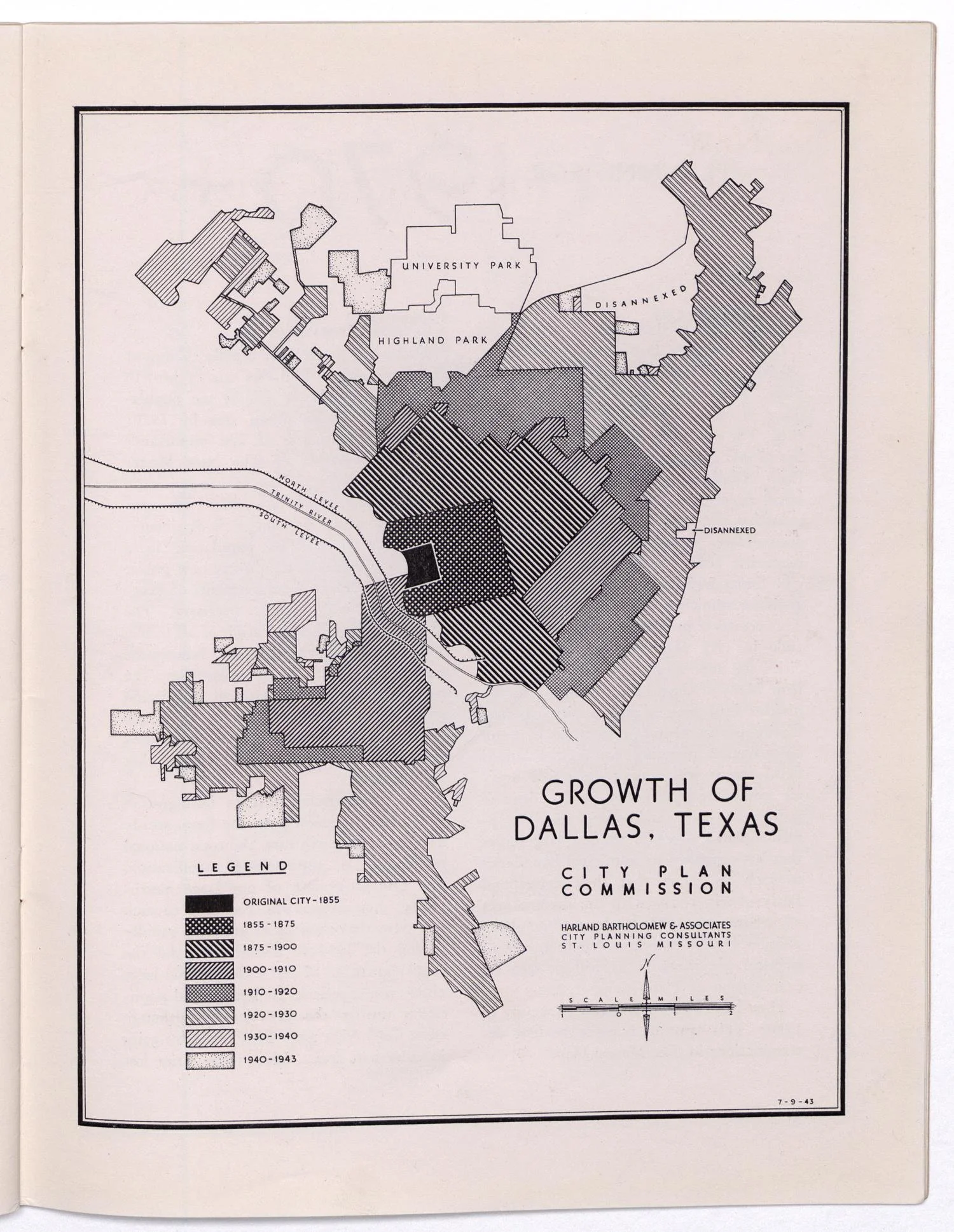
Figure 13: Growth of Dallas (Source: UNT Libraries)
Because the vast majority of new post-war growth had been sprawling, automobile-dependent, and suburban in nature—the city had gone from 50 square miles at the beginning of 1945, to 198 square miles at the end of 1955[58]—far more new infrastructure was needed to support it than had been necessary for previous waves of growth, which had generally been built more densely along existing corridors and with streetcar travel in mind.[59] For the emerging sprawl, roads needed to be built, sewers and utilities needed to be extended, and land needed to be prepared. Furthermore, immediately after the war, the GI Bill had significantly accelerated suburbanization by providing veterans with low-interest, no-down-payment home loans, enabling millions to buy houses in the newly built suburbs (and incentivizing developers to build even more tract housing to keep up with the demand). While Black veterans were technically eligible, in practice few were able to take advantage of the bill’s provisions due to the preexisting policies of redlining, restrictive covenants, etc.[60]
While the strain on the city’s finances was largely the result of suburban-style growth, its impacts were felt most acutely by the city’s Black residents—the city’s Black Belt, some of the oldest neighborhoods in the city, were in desperate need of reinvestment as physical conditions worsened. Moreover, by 1950, “despite the fact that they constructed more than 30,000 new homes between 1945 and 1949, private builders erected fewer than 1,000 new dwellings for blacks, although Greater Dallas’s black population increased by 30,000 between 1940 and 1950,” Fairbanks writes.[61] “Not only did little new black housing appear, but completed public works projects such as the construction of the Central Expressway and the expansion of Love Field actually destroyed black housing.”[62] In the meantime, Black residents were “hemmed in by the iron curtain of segregation,” said G.F. Porter of the local NAACP, exacerbated by overcrowding and cuts to municipal services.[63]
PART 8: FEDERAL FUNDING (1950s – 1970s)
By the 1950s, Dallas was not alone in these problems. In cities around the country, the continuing Great Migration and post-war white flight had begun to upend established spatial and transportation patterns, strained city finances, and created fears of declining downtowns surrounded by a racialized “inner city,” a dog-whistle term popularized in the 50s referring to the racially transitioning neighborhoods that suburbanites had left behind.[64] In turn, the inner city itself was surrounded by whites-only suburbs. Rothstein writes, “scores of racially explicit laws, regulations, and government practices combined to create a nationwide system of urban ghettos, surrounded by white suburbs.”[65]
As in Dallas, municipal leaders around the country feared the loss of Downtown property values and looked to similar practices as those which Harland Bartholomew promoted, with cities including Los Angeles, Fort Worth, St. Louis, Rochester (NY), San Antonio, and Washington DC having hired his firm directly to create plans.[66] Planners also increasingly looked to the example of Robert Moses in New York City, the famed “master builder” who had implemented similar designs across the region, promoting exclusionary zoning in suburban Long Island, and connecting those suburbs to the Manhattan and Brooklyn CBDs with highways that had cut through immigrant and non-white neighborhoods. Influenced by the work of Bartholomew (as well as more grandiose historic examples such as Haussman), “Moses believed infrastructure projects like highways could not only be used to clear blight and slums, but that those same highways could also provide semi-permanent physical barriers to keep people of color separate from white communities, ensuring that the blight that they produced would never harm white communities again.”[67]
Moses’ lobbying, along with the advocacy of others such as Thomas H. MacDonald (chief of the federal Bureau of Public roads from 1919 – 1953), Bertram Tallamy (the first federal highway administrator in 1956), and Charles Erwin Wilson (head of GM and Secretary of Defense under Eisenhower), proved instrumental in increasing direct federal support for highway construction and urban renewal.[68] Their efforts culminated in the 1956 Federal Aid Highway Act (also referred to as the Interstate Highway Act) which officially standardized the Interstate Highway network and would provide cities with a staggering 90% federal match for highway projects, with a total of $25 billion budgeted over ten years ($220 billion today).[69] Similar lobbying had also helped create the earlier 1949 Federal Housing Act, which provided a 66% federal match for “slum clearance and urban renewal” programs, leveraging the same racially coded language of “blight elimination,” with a total budget of $1.5 billion ($20.5 billion today). With the availability of these two massive pots of federal money, cities around the country were able to not only realize existing master highway plans, but to significantly augment them with additional highways—nearly entirely on the federal government’s dime. Accompanying the 1956 bill was the famous “Yellow Book,” officially the “General Location of National System of Interstate Highways,” a publication which provide city-by-city recommendations for the siting of the new Interstate. The Yellow Book was co-written ny Wilson (the head of GM until 1953) and was partially based on earlier recommendations from the more limited 1944 Federal Aid Highway Act. The 1944 Act had been developed by a commission appointed by FDR in 1941, which included none other than Harland Bartholomew as one of its seven members.[70] Unsurprisingly, the Yellow Book entry for Dallas featured a Downtown highway plan similar to the 1943 Bartholomew plan (Figure 14).
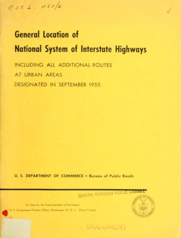
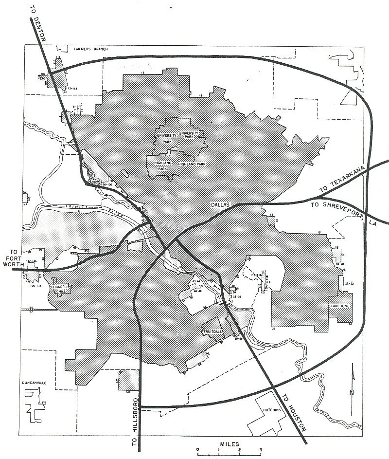
Figure 14: Dallas “Yellow Book” Entries (Source: Wikimedia Commons)
Despite the availability of federal money to complete the implementation of the master plan, the DCC was initially reluctant to accept money from the federal government, apparently reflecting their conservative ideology. “In spite of the lure of all that new land sitting out there, raw and unused once blacks were removed,” writes Schtuze, “some Dallas leaders balked at the use of government force to take private property… the scheme would require a massive resort to two commodities that were supposed to be alien to the Dallas do-it-yourself philosophy—public seizure of private property, and money from the Federal Government.”[71] Ultimately, this reluctance was short-lived, with the promise of a federal carte blanche proving far more persuasive than performative ideology. Schutze writes, “In spite of the little fibs it tells about itself [concerning fiscal probity], Dallas didn’t turn down much from Washington… Dallas leaders not only took the federal money, they begged for it.”
Schutze continues, describing how civic leaders were incentivized to maximize municipal infrastructure plans to take advantage of the moment created by the new legislation: “In 1951, [DCC executive] John Stemmons was right up there in Washington with the best of them, holding out his hands to the House Appropriations Committee. Why shouldn’t he have been? The federal government was slopping the hogs then, pouring hundreds of millions of dollars out across the countryside in slum clearance money, flood control appropriations, and highway funds. Dallas would never compare with cities like New York, where Robert Moses was creating a private kingdom of federally subsidized public works projects. But Dallas wouldn’t do badly, either.”[72]
For their part, the DCC viewed this “compromise” as necessary to achieve their stated aim of advancing the interests of the “city as whole,” a phrase members commonly employed but never precisely defined. Fairbanks writes, “For the city to prosper, the argument went, blacks and whites needed to act in the best interests of the city, even if meant sacrificing one’s own agenda. For the public welfare, blacks would stay in delegated areas and conservative whites would turn to the federal government for help.”[73] (It is worth noting the staggering asymmetry in the elements of this “compromise,” with Black residents forced to accept the indignity of confinement, while white leaders were “forced” to accept the “indignity” of taking federal money.)
PART 9: “THE ACCOMMODATION” (1954s – 1980s)
Another factor in obviating the DCC’s reluctance to accept federal aid beginning in the 50s was the ongoing specter of federal integration trickling down from the courts and Congress, which the city’s elites feared would worsen the already fraying racial peace—bombings in South Dallas had continued as more and more displaced Black residents arrived (Figure 15).[74] Starting with the Brown v. Board of Education Supreme Court ruling, beginning school integration in 1954; and culminating in the Civil Rights Acts of 1964 and 1968, which all but ended most legal segregation policies, Dallas was entering an era in which it could no longer formally rely on practices like restrictive covenants and the enforcement of “sundown town” rules to contain the Black population.
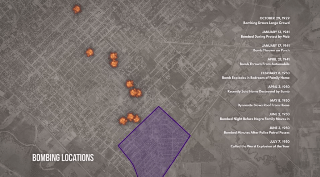
Figure 15: Map of South Dallas racial bombings in the 1950s, part of a campaign of intimidation against Black residents moving into South Dallas. (Source: “The Story of Racial Equity in Dallas.)
Archer writes, “The nation’s interstate highway system’s routes were adjusted, finalized, and ultimately built against the backdrop of the massive resistance to integration that Brown [v. Board] inspired. [Highways] became an essential element of the resegregationist agenda. Just as the laws and norms that provided the legal and intellectual basis for segregation were falling to the civil rights movement, the Interstate Highway Act presented many governors, mayors, and city planners with a means of fighting back… the physical boundaries they created would withstand the adoption and evolution of civil rights laws that followed the decision in Brown. Segregationists may have had to comply with the new civil rights laws, but the highways became a new body of ‘laws’ unto themselves.”[75]
In Dallas, actual desegregation was to be “ceremonial,” designed to “avoid riot at all cost,” said Stanley Marcus, DCC Member and Chairman of Board of Neiman Marcus.[76] Business leaders were particularly afraid of unrest similar to what had ensued in Little Rock during that city’s attempts at school desegregation in 1957. When the Governor of Arkansas Orval Faubus had attempted to prevent Black students in Little Rock from entering an all-white school (despite federal orders for desegregation), President Eisenhower invoked the Insurrection Act, ordering US Army troops to enforce integration and escort the students to school.[77] The incident had severely damaged Little Rock’s national image (Figure 16)—a fate the DCC hope to avoid in Dallas.
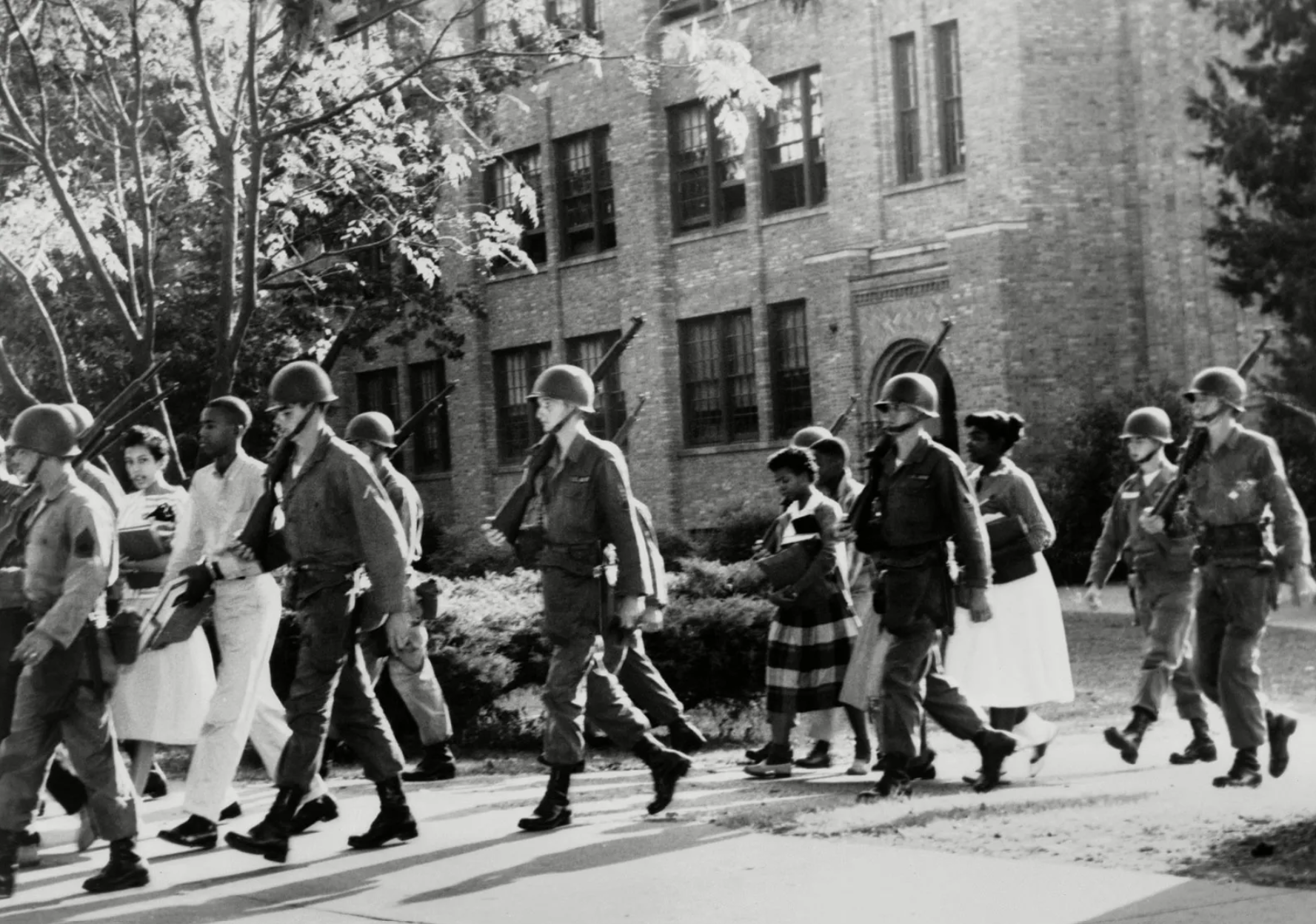
Figure 16: The DCC hope to avoid a “Little Rock” situation, in which federal troops had been sent in to assist with court-ordered school desegregation (Source: Encyclopedia Britannica)
For the city’s leadership, desegregation provided new urgency for the completion of the master plan and the “racial peace” they hoped it could achieve through a combination of Black containment and white suburbanization.[78] With federal money in hand, Dallas leaders worked with the Texas Highway Commission to build the loop of highways around Downtown, displacing thousands across Deep Ellum, Oak Cliff, Mexicantown, and old North Dallas, and reorienting the core towards the growing suburbs. The commercial and entertainment center of Deep Ellum, which had already been impacted by the construction of the Central Expressway in 1950s, was entirely demolished for a southern extension (the expressway had formerly dead-ended on Elm Street), today I-345 and 45. This southern extension also cut through the rest of South Dallas, displacing hundreds more (Figures 17 and 18).[79]
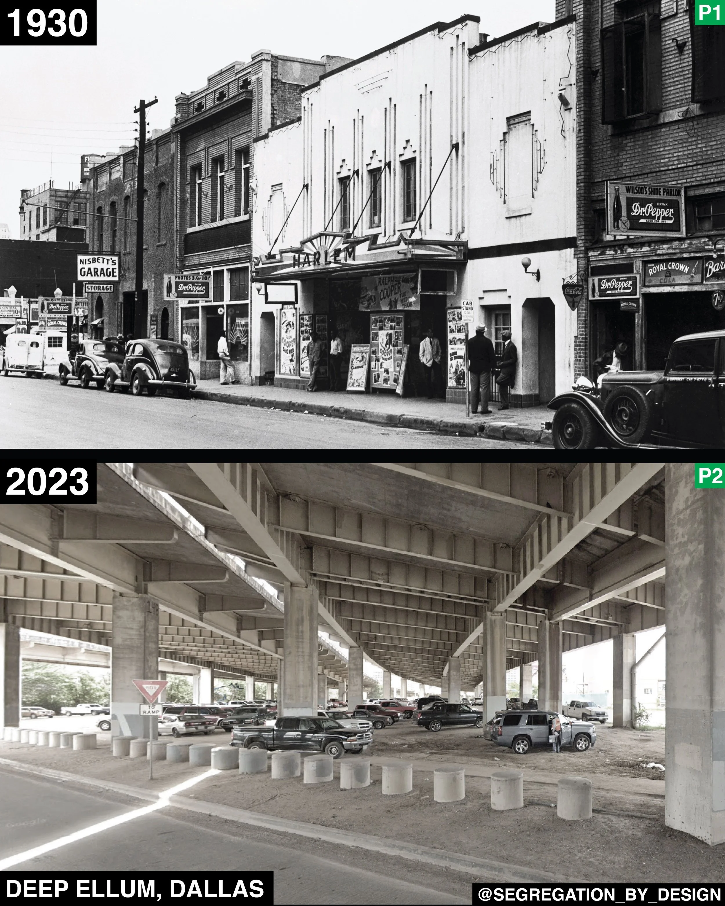
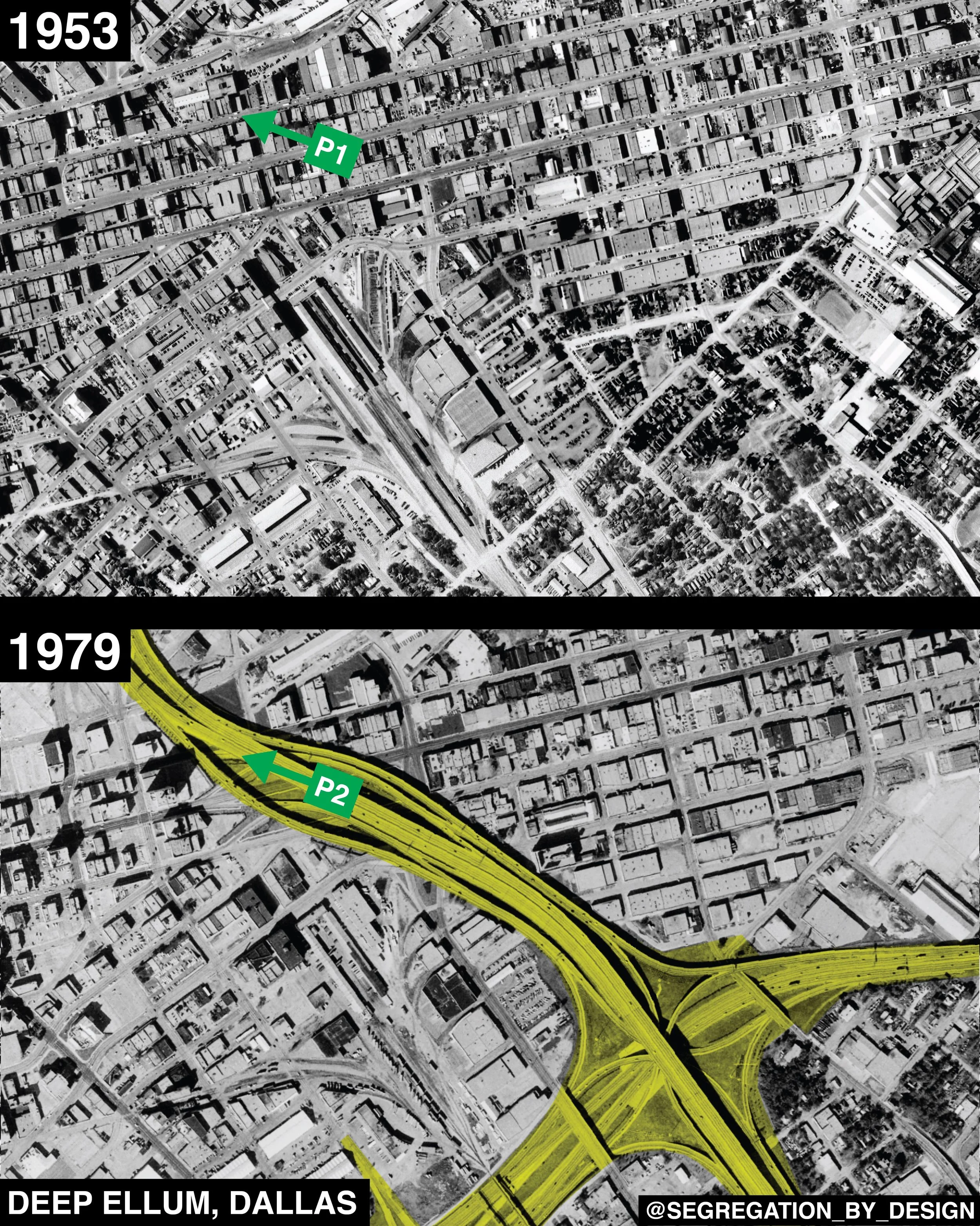
Figure 17: Deep Ellum before-and-after construction of the southern extension of the Central Expressway (Source: Author)
I-30 cut east-west on a path just south of the Downtown core, intersecting the Central Expressway at a massive interchange that would replace most of the housing in the residential section just south of Deep Ellum (Figure 20), and leave the rest of South Dallas divided from both Deep Ellum and Downtown. The structure of the highway itself, a sunken trench over 600’ at certain points, is today known as “the Canyon.”[80] I-30 would continue across the Trinity River into Oak Cliff, similarly flattening much of the Freedman’s Town that had developed there.
On the north end of Downtown, the Woodall Rogers Freeway would cut through Little Mexico and what remained of Stringtown, with adjacent urban renewal projects seeing the neighborhood largely reduced to parking lots (and setting the stage for the area’s eventual redevelopment and rebranding as “Uptown”)(Figure 19).
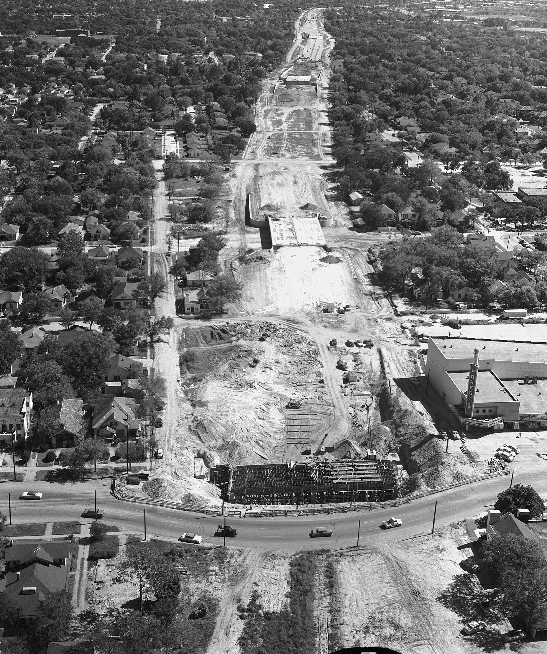
Figure 18: Construction of the southern extension of the Central Expressway (source: Flashback Dallas)
By the early 60s, with these plans in motion and Dallas having seemingly avoided some of the worst of the racial unrest that had rocked cities such as Detroit, Baltimore, and Chicago, as well as having reduced the incidence of bombings in South Dallas, DCC leaders were confident of their success. Schutze writes, in the eyes of the DCC, “The peace was glued back together, the city was saved, and the economy began its long flat race into the glistening dream. The buildings were being built. The industrial district boomed… The poor blacks lost their homes, lost their land, and had to live in government concentration centers [what Schutze calls the projects], but the better off ones, the ones who had enough money to cause trouble, were given new neighborhoods, and, eventually, they got South Dallas, too. The less affluent whites may have needed more time and more push, but they finally fled South Dallas rather than live near black people. The evacuation was swift and total when it came. The white people who couldn’t afford to move to the rapidly developing [suburban] neighborhoods of North Dallas… moved to little communities just outside the city… refuges where white people could keep their jobs in the city and, at the same time, stay as far away as possible from its increasingly ‘urban’ ethos.”[81] The highways, ultimately, would make this pattern possible.
The appearance of peace on the surface hid the reality of economic disaster for Dallas’ Black community. A 1960s Dallas Morning News article, written shortly before much of Deep Ellum was demolished for the southern extension of the Central Expressway, found a still-lively district occupied by the same businesses that had been there for decades. The article interviewed local business owners who placed the blame for the neighborhood’s downfall squarely on the highway: “When the freeway comes it will cut the heart out of the district.” This assessment was correct, and much of the land the neighborhood formerly occupied is now a no-man’s land of highway ramps and roadway viaducts.
So complete was the destruction of the neighborhood, and so immediately did Dallasites see the new highways as an immutable feature of the landscape—almost as if they were natural formations—that a few years later, in another article from the Dallas Morning News, “reporter Roy Hamric is completely baffled by the mysterious cause of the neighborhood’s hard fortunes, despite the looming presence of brand new I-345,” writes Peter Simek for D Magazine. The 1971 article says, “Nobody knows exactly when the robust surge of life that was ‘Deep Ellum’ left—or exactly why—but traces of what once ‘the Street’ remain today,” Hamric writes, before dismissing the road as the cause.[82]
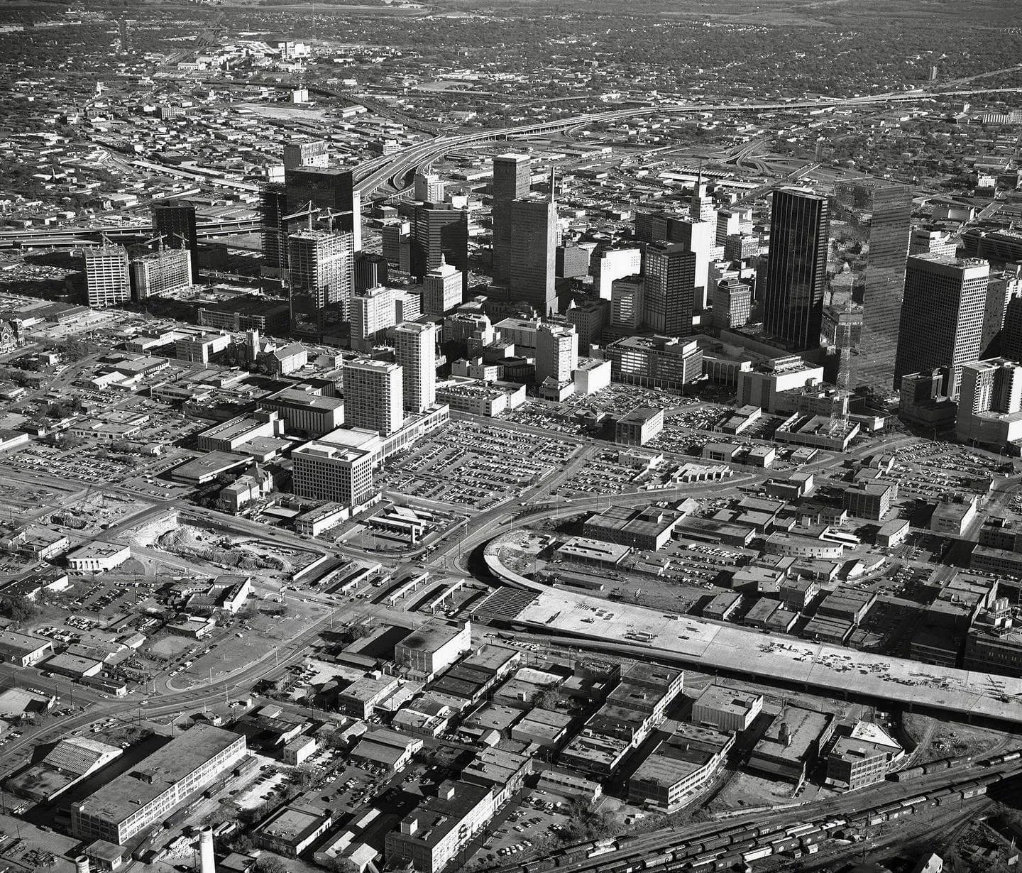
Figure 19: Construction of the Woodall Rodgers Freeway through Little Mexico (Source: Flashback Dallas)
PART 10: HYPERGHETTOIZATION (1980-2000)
By the 1980s, for the city’s Black population, having been displaced from Freedman’s Town and Stringtown to the north of Downtown, and now largely confined to South Dallas, the Fair Park area, and other pockets throughout the city, the forces of urban deindustrialization and neoliberalization would exacerbate the economic immiseration resulting from spatial containment.
The logic of racial containment was at least in part based on a desire to extract useful labor from the city’s Black population at low cost compared with white labor. The city’s leaders did not want the city’s Black districts to grow beyond their control, but nor did they want them completely eliminated due to the cheap labor pool they provided. Indeed, throughout Dallas’ history, Black workers had played a critical role in providing the physical manpower to build and maintain industries such as the railroads and manufacturing that served as the engine for the city’s growth.
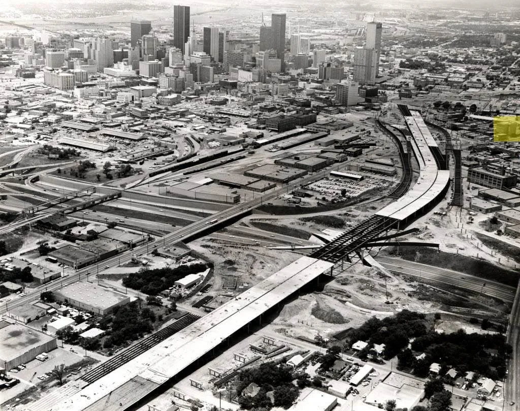
Figure 20: Construction of the interchange between I-30 and the Central Expressway (Source: D Magazine)
Influential Swedish economist Gunnar Myrdal noted of pre-war segregation in his landmark 1944 study, “An American Dilemma: The Negro Problem and Modern Democracy” (which was influential in the Brown v. Board Supreme Court Decision), even “Southern whites do not want Negroes to be completely isolated from them: they derive many advantages from their proximity… there is also segregation, but the segregation is based on what me may term ‘ceremonial’ distance rather than spatial distance.”[83] Examples of this “ceremonial distance” include the separate facilities for Black and white people in Southern public spaces during the era of Plessy-style segregation. While this ceremonial distance of course resulted in the daily humiliation of Black and brown residents, at an urbanistic and architectural level, different races still mixed in close proximity in “shared” public spaces.
In the post-war and post-Brown era of the 50s-80s, the jurisprudence upholding “ceremonial” distance had fallen, and in its stead spatial distance had been realized through suburbanization (having been made technically possible through automobilization). While the implementation of this arrangement had brought significant destruction to city’s Black neighborhoods through highway construction during the 50 and 60s, the continued availability of Downtown jobs for low-skilled workers meant that these areas still held promise for many Black residents seeking work.[84] Moreover, if the DCC was successful at “saving” the Downtown core as it had aimed to (while also boosting industrial growth), Black residents still theoretically stood to gain (somewhat) from the economic opportunities, even if the commercial spaces and factories in which they worked took up space formerly occupied by housing, and even if the physical routes to those jobs were treacherous. Unfortunately, the DCC’s plan was not successful.
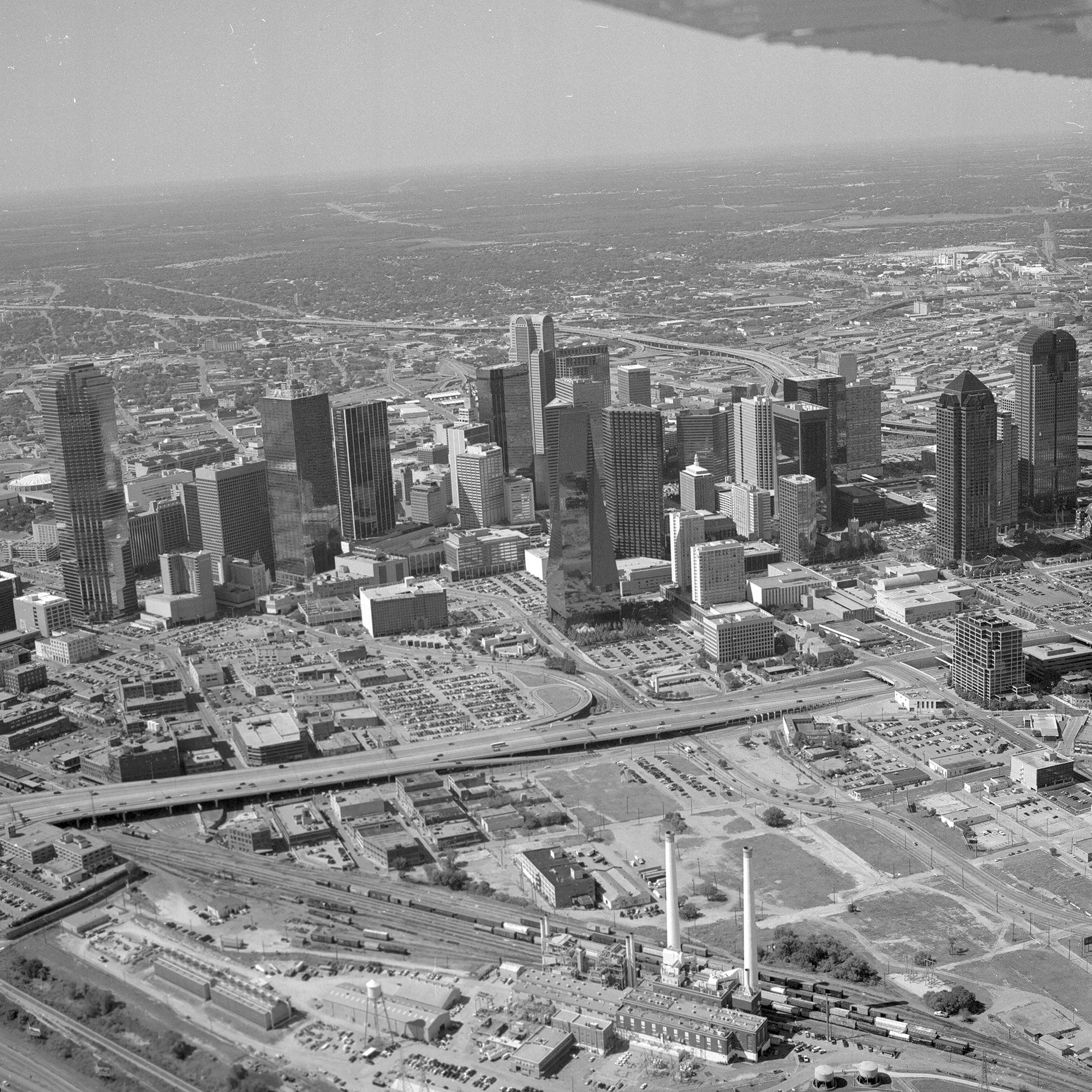
Figure 21: Downtown Dallas, 1990—empty office towers, abandoned factories… but plenty of parking. (Source UTA Libraries)
In an attempt to retain Downtown businesses and continue the primacy of the area as the economic core, the DCC had overseen the complete, federally-funded overhaul of the CBD to make it more accessible for suburban commuters, a process which was largely complete by the late 80s. Instead, businesses themselves had followed the highways to suburbs, relocating to the new office parks spreading across the landscape. “Manufacturing, wholesaling, large-scale retail, commercial back-office space, as well as corporate headquarters—all have moved to suburbia and exurbia… by 1988 over 70% of the commercial office in Dallas space lay outside the CBD.”[85] For Black residents, the jobs they had been seeking when they had moved the city in the first place were now being relocated to the inaccessible suburbs—or, increasingly, being “outsourced” overseas.
Prior to this period, Black neighborhoods adjacent to Downtowns served a similar function as imperial colonies, Marcuse writes, “The colonies are linked to the colonizers; the masters have an interest in (profit from) the work of the subject peoples.” The decentering resulting from suburbanization, combined with the forces of globalization which saw the rapid de-industrialization of much of the United States as a whole, eliminated this relationship. “That is what has changed in the post-Fordist city,” Marcuse writes, referring to the evolution of industry in this period from a more vertically-integrated and centralized model, to one based on specialization, cost-cutting, and “efficiency” (for instance through the increased use of contractors rather than full-time staff).
In the Post-Fordist landscape, where place became increasingly irrelevant as businesses could outsource work to cheaper locations, “black ghettos were no longer productive for their masters; their masters get no benefit from their existence. As far as the dominant society is concerned, they are only a drain on public and private resources, they are a threat to social peace, and they fulfill no useful social role. They are outcasts… the appropriate historical analogy for the outcast ghetto is more the leper colony than the medieval Jewish ghetto.”[86]
Like so many similar neighborhoods across the country, with the loss of jobs and de-industrialization of the core, what remained of Deep Ellum, South Dallas, the Fair Park Area, and Oak Cliff, had become “outcast ghettos,” which Marcuse defines as “a ghetto in which ethnicity is combined with class in a spatially concentrated area with residents who are excluded from the mainstream of economic life of the surrounding society, which does not profit significantly from its existence.”[87] The physical divisions created by the highways only exacerbated this economic separation, while also further draining economic vitality from the core.
PART 11: GENTRIFICATION/CONCLUSION
In 2013, Ta-Nehisi Coates wrote, “It is increasingly clear to me that white flight was not a mystical process for which we have no real explanation or understanding. White flight was the policy of our federal, state, and local government. That policy held that Americans should enjoy easy access to cities via the automobile and live in suburbs without black people, who by their very nature degraded property and humanity.”
In the process of realizing that policy, in Dallas as in so many other cities, leaders had essentially destroyed the Downtown core, replacing the urban fabric with new roads, parking, and office space for commuters who were increasingly getting new jobs in the suburbs anyway. As the highways were being completed in the late 70s, the DCC had encouraged a building boom of downtown skyscrapers—which, by the late 80s, were sitting almost a quarter empty, at 23% occupancy.[88] To the north of Downtown, the residential areas of Mexicantown and the North Dallas Freedman’s Town that found themselves on the inside of the highway loop had been leveled in anticipation of future office-towers that never came.
In the early 1990s the Savings and Loan crisis worsened the situation, with office vacancy rising to 35%—the highest in the nation (“higher than Detroit,” leaders were mortified to note).[89] Because of this crisis, Dallas leaders “began considering options that previously would have been regarded as heresy”: building back housing Downtown.[90] This time, however, urban housing would be focused on the increasing numbers of upper-middle class professionals who had become disenchanted with obvious failings of suburban living—the lack of social and cultural institutions, the overbearing homogeneity, and, of course, the endless traffic. In other words, Dallas leaders sought to gentrify. In this effort, they would succeed.
Tellingly, the first special district in the Downtown area created to support the development of new housing was in 1990 around the old Thomas and Hall Area, formerly the core of the North Dallas Freedman’s Town, by then home to only remnants of the community—who would soon be displaced by upscale housing.[91] With the gentrification of the areas immediately north of Downtown Dallas, both within the loop and outside of it, the division created by the Woodall Rogers Freeway (the northern portion of the loop) came to no longer be seen as a protective asset, but rather something which could inhibit even further gentrification. It is perhaps no surprise, then, that “capping” much of the Woodall Rogers has been prioritized, with the Klyde Warren Park opening above the highway in 2012 and future expansions set to begin construction soon.[92] Whereas on the South and East of Downtown, in still largely Black South Dallas, Fair Park, and Old East Dallas, the I-30 and the Central Freeway continue to act as barriers. More on these neighborhoods to come.
Endnotes
[1] “Social Explorer,” Social Explorer, accessed March 4, 2026, https://www.socialexplorer.com/my-home.
[2] KERA, “Big D Back When,” 2013, https://www.youtube.com/watch?v=p-n5-8giHfo.
[3] Richard Rothstein, The Color of Law: A Forgotten History of How Our Government Segregated America (W.W. Norton & Company, 2017), 92.
[4] Deborah N. Archer, Dividing Lines: How Transportation Infrastructure Reinforces Racial Inequality, First edition (W.W. Norton & Company, 2025), 28.
[5] N. D. B. Connolly, A World More Concrete: Real Estate and the Remaking of Jim Crow South Florida, Historical Studies of Urban America (The University of Chicago Press, 2014), 8.
[6] Texas State Historical Association, “A Comprehensive History of Dallas, Texas,” Texas State Historical Association, accessed March 4, 2026, https://www.tshaonline.org/handbook/entries/dallas-tx.
[7] Collin Yarbrough, Paved A Way Infrastructure, Policy and Racism in an American City (New Degree Press, 2021), 26.
[8] Collin Yarbrough, Paved A Way Infrastructure, Policy and Racism in an American City (New Degree Press, 2021), 38.
[9] Rothstein, The Color of Law: A Forgotten History of How Our Government Segregated America, 22.
[10] Collin Yarbrough, Paved A Way Infrastructure, Policy and Racism in an American City (New Degree Press, 2021), 39.
[11] “Collin Yarbrough, Paved A Way Infrastructure, Policy and Racism in an American City (New Degree Press, 2021), 39.
[12] “Collin Yarbrough, Paved A Way Infrastructure, Policy and Racism in an American City (New Degree Press, 2021), 41.
[13] “Collin Yarbrough, Paved A Way Infrastructure, Policy and Racism in an American City (New Degree Press, 2021), 42.
[14] Kathryn Holliday, “Mapping Inequality,” accessed March 4, 2026, https://dsl.richmond.edu/panorama/redlining/.
[15] Holliday, “Mapping Inequality.”
[16] KERA, Big D Back When.
[17] “The Story of Racial Equity in Dallas, Texas,” ArcGIS StoryMaps, September 23, 2025, https://storymaps.arcgis.com/stories/f8ad4376d6d14ff0b3566fcc3ce0ff9c.
[18] By Darwin Payne, “How Dallas Morning News Led the Fight Against the Klu Klux Klan,” D Magazine, May 22, 2017, https://www.dmagazine.com/publications/d-magazine/2017/june/when-dallas-was-the-most-racist-city-in-america/.
[19] Wilkerson, Isabel. The Warmth of Other Suns : the Epic Story of America's Great Migration. New York :Vintage Books, 2011.
[20] Robert B. Fairbanks, For the City as a Whole: Planning, Politics, and the Public Interest in Dallas, Texas, 1900-1965, Urban Life and Urban Landscape Series (Ohio State University Press, 1998), 64.
[21] “Nadir of American race relations,” Wikipedia, February 20, 2026, https://en.wikipedia.org/w/index.php?title=Nadir_of_American_race_relations&oldid=133951357
[22] Fairbanks, For the City as a Whole, 152.
[23] Texas State Historical Association, “The Rise and Fall of Ku Klux Klan No. 66 in Dallas,” Texas State Historical Association, accessed March 4, 2026,
https://www.tshaonline.org/handbook/entries/dallas-ku-klux-klan-no-66.
[24] Jim Schutze, The Accommodation: The Politics of Race in an American City, with John Wiley Price (Deep Vellum Publishing, 2021), 6.
[25] Texas State Historical Association, “The Dallas Citizens Council: Shaping Dallas Through the Decades,” Texas State Historical Association, accessed March 4, 2026, https://www.tshaonline.org/handbook/entries/dallas-citizens-council.
[26] Payne, “How Dallas Morning News Led the Fight Against the Klu Klux Klan.”
[27] Schutze, The Accommodation, 6.
[28] Association, “The Dallas Citizens Council.”
[29] “Planning History Timeline,” American Planning Association, accessed March 4, 2026, https://www.planning.org/timeline/.
[30] Rothstein, The Color of Law: A Forgotten History of How Our Government Segregated America, 63.
[31] Schutze, The Accommodation, 6.
[32] Joseph Heathcott, “‘The Whole City Is Our Laboratory’: Harland Bartholomew and the Production of Urban Knowledge,” Journal of Planning History 4, no. 4 (2005): 322–55, https://doi.org/10.1177/1538513205282131.
[33] Rothstein, The Color of Law: A Forgotten History of How Our Government Segregated America, 95.
[34] Rothstein, The Color of Law: A Forgotten History of How Our Government Segregated America, 97.
[35] Wilkerson, The Warmth of Other Suns.
[36] Peter D. Norton, Fighting Traffic: The Dawn of the Motor Age in the American City, Inside Technology (MIT Press, 2011).
[37] Fairbanks, For the City as a Whole, 134.
[38] Mimi Sheller, Mobility Justice, 2020.
[39] Fairbanks, For the City as a Whole, 134.
[40] Norton, Fighting Traffic.
[41] Norton, Fighting Traffic.
[42] David Harvey, Rebel Cities: From the Right to the City to the Urban Revolution (Verso, 2012).
[43] Fairbanks, For the City as a Whole, 134.
[44] Archer, Dividing Lines, 30.
[45] Fairbanks, For the City as a Whole, 134.
[46] Archer, Dividing Lines, 25.
[47] “Appler - 2023 - The Many Geographies of Urban Renewal New Perspectives on the Housing Act of 1949,” 2017, 196. https://academic.oup.com/jah/article-abstract/112/1/186/8162631?redirectedFrom=fulltext
[48] Schutze, The Accommodation, 34.
[49] Schutze, The Accommodation, 163.
[50] “Collin Yarbrough, Paved A Way Infrastructure, Policy and Racism in an American City (New Degree Press, 2021), 84.
[51] George E. Kessler, “[A City Plan for Dallas],” Book, The Portal to Texas History, Dallas (Tex.). Park and Recreation Department., 1911, United States - Texas - Dallas County - Dallas, https://texashistory.unt.edu/ark:/67531/metapth129158/m1/.
[52] “Deep Ellum: Life Along Central Track,” Flashback : Dallas, February 20, 2024, https://flashbackdallas.com/2024/02/20/deep-ellum-life-along-central-track/.
[53] Recovering the Stories: Exploring the History and Resilience in Dallas Communities | Freedman’s Town | Recovering the Stories, 2024, accessed March 4, 2026, https://video.kera.org/video/freedmans-town-recovering-the-stories-i6w7dr/.
[54] “Collin Yarbrough, Paved A Way Infrastructure, Policy and Racism in an American City (New Degree Press, 2021), 46.
[55] “Collin Yarbrough, Paved A Way Infrastructure, Policy and Racism in an American City (New Degree Press, 2021), 46.
[56] Fairbanks, For the City as a Whole, 172.
[57] Fairbanks, For the City as a Whole, 174.
[58] Fairbanks, For the City as a Whole, 172.
[59] Norton, Fighting Traffic.
[60] “Not All WWII Veterans Benefited Equally from the GI Bill,” accessed March 5, 2026, https://heller.brandeis.edu/news/items/releases/2023/impact-report-gi-bill.html.
[61] Fairbanks, For the City as a Whole, 191.
[62] Fairbanks, For the City as a Whole, 192.
[63] Fairbanks, For the City as a Whole, 191.
[64] Bench Ansfield, “Unsettling ‘Inner City’: Liberal Protestantism and the Postwar Origins of a Keyword in Urban Studies,” Antipode 50, no. 5 (2018): 1166–85, https://doi.org/10.1111/anti.12394.
[65] Rothstein, The Color of Law: A Forgotten History of How Our Government Segregated America, 12.
[66] Heathcott, “‘The Whole City Is Our Laboratory.’”
[67] Archer, Dividing Lines, 35.
[68] Archer, Dividing Lines, 33.
[69] “Federal-Aid Highway Act of 1956,” Wikipedia, December 11, 2025, https://en.wikipedia.org/w/index.php?title=Federal-Aid_Highway_Act_of_1956&oldid=1326812600.
[70] “One Man Zoned Huge Swaths of Our Region for Sprawl, Cars, and Exclusion,” Greater Greater Washington. accessed March 5, 2026, https://ggwash.org/view/70408/harland-bartholomew-the-man-who-zoned-washington-dc.
[71] Schutze, The Accommodation, 61.
[72] Schutze, The Accommodation, 62.
[73] “Fairbanks - 1998 - For the City as a Whole Planning, Politics, and the Public Interest in Dallas, Texas, 1900-1965,” 164.
[74] ArcGIS StoryMaps, “The Story of Racial Equity in Dallas, Texas.”
[75] Archer, Dividing Lines, 28.
[76] Schutze, The Accommodation, 62.
[77] “Little Rock Nine,” Wikipedia, January 18, 2026, https://en.wikipedia.org/w/index.php?title=Little_Rock_Nine&oldid=1333562285#National_Guard_blockade.
[78] ArcGIS StoryMaps, “The Story of Racial Equity in Dallas, Texas.”
[79] Holliday, “Mapping Inequality.”
[80] Matt Goodman, “A Look At I-30’s Hopes in The Canyon: Deck Parks, Complete Streets, and More,” D Magazine, October 31, 2019, https://www.dmagazine.com/frontburner/2019/10/txdot-dallas-interstate-30-canyon/.
[81] Schutze, The Accommodation, 76.
[82] Peter Simek, “What We Really Lose When Highways Destroy Historic Neighborhoods,” D Magazine, June 15, 2021, https://www.dmagazine.com/frontburner/2021/06/what-we-really-lose-when-highways-destroy-historic-neighborhoods/.
[83] “Marcuse-1997-the-Enclave-the-Citadel-and-the-Ghetto-What-Has-Changed-in-the-Post-Fordist-u-s-City,” n.d., 234.
[84] “Marcuse-1997-the-Enclave-the-Citadel-and-the-Ghetto-What-Has-Changed-in-the-Post-Fordist-u-s-City,” 237.
[85] “Temporary Contracts,” Harvard Design Magazine, 2020, accessed March 5, 2026, https://www.harvarddesignmagazine.org/articles/temporary-contracts/.
[86] “Marcuse-1997-the-Enclave-the-Citadel-and-the-Ghetto-What-Has-Changed-in-the-Post-Fordist-u-s-City,” 236.
[87] “Marcuse-1997-the-Enclave-the-Citadel-and-the-Ghetto-What-Has-Changed-in-the-Post-Fordist-u-s-City,” 238.
[88] Loessberg, Rick. “Eighteen Years Later: Catching up with Dallas’ In-Town Hosuing Program.” The IEDC Economic Development Journal, accessed March 5, 2026, https://www.iedconline.org/clientuploads/Economic%20Development%20Journal/EDJ_12_Fall_Loessberg.pdf.
[89] Loessberg, Rick.
[90] Loessberg, Rick.
[91] Loessberg, Rick.
[92] Megan Kimble. “Plotting the Death of a Texas Highway.” Bloomberg Citylab, April 24, 2024. https://www.bloomberg.com/news/features/2024-04-02/dallas-debates-fate-of-the-downtown-highway-that-divided-the-city?srnd=citylab-transportation&sref=0IejgNtz