
FREEPORT, NASSAU COUNTY
Posted October 28, 2026
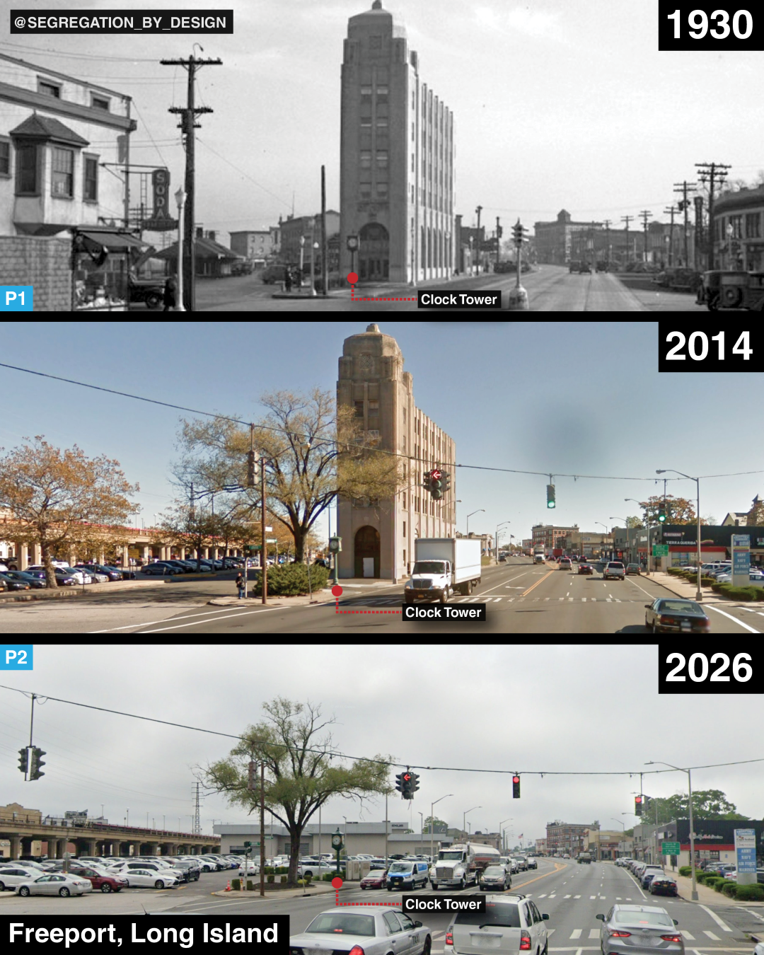
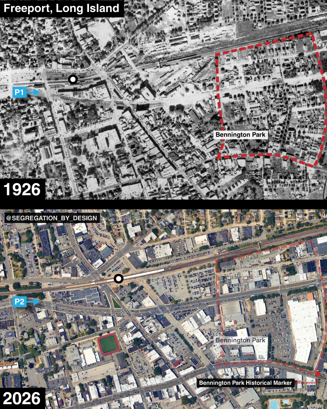
Freeport, Long Island, before-and-after 1960s urban renewal, which saw the town’s historic, mixed-use buildings around the LIRR station replaced with commuter parking. Adjacent to the station, the residential neighborhood of Bennington Park—home to the majority of the town’s Black population—was also destroyed through the publicly-funded urban renewal program. 1000 people were displaced and 250 homes demolished, replaced with parking for two new “big-box” centers (i.e., “power centers”)[1][2]. The art deco Meadowbrook Bank Building, seen in the first image, had been one of the last vestiges of Freeport’s more urban past, and a reminder of when it aspired for a more ambitious future. It was demolished in 2018 for a Lexus dealership.
I’ve been thinking about towns like Freeport in suburban Long Island in response to a simple question the other day, “How would NYC look different if Robert Moses hadn’t built the highways”? Impossible to fully answer, but I actually think NYC wouldn’t look fundamentally different—it’s the suburbs that would.
Within the city, of course, there’d still be significant differences: there’d be a quarter million people (disproportionately Black and Latino) who would’ve had a chance to continue building generational wealth had RM not robbed them of their homes. This would’ve had profound impacts on the institutional and cultural landscape. Physically, however, NYC has remained recognizably “urban,” even in spite of RM’s projects. The city would have less car traffic and air pollution without RM; but try as he might, New York remains a bastion of walkability, urban density, and class/racial diversity when compared with the rest of US cities.
Instead, it’s suburbs like Freeport and the region at large that would look radically different without RM-style highway construction. Moses’ Long Island highways were built partially as a response to increased residential white flight, designed to connect existing suburbs with Manhattan jobs. But the highways were also a catalyst, cutting new automobile-only corridors through open land far from the existing “legacy” suburbs clustered around the train lines.[3]
Cutting highways through open farmland far from existing transit lines—combined with the widespread adoption of single-family zoning across Nassau County—encouraged rapid residential sprawl away from existing nodes, typified in places like Levittown. Whereas New York’s older suburbs like Freeport formerly were essentially small cities in their own right—dependent on the railroad connection to NYC for their economic livelihood, but containing miniature job-rich and mixed-use “Downtowns” centered on the RR station—post-highway development was almost exclusively single-family homes (like Levittown, complete with racially restrictive covenants) with limited, automobile-based commercial areas [4].
As in the cores of larger cities, older suburbs like Freeport underwent white flight to these newer, racially-restricted houses, leaving behind a growing number of Black and Latino residents moving into the apartments and rowhouses they vacated, expanding the legacy communities of mostly Black railroad and domestic workers such as Bennington Park in Freeport, and others in Hempstead, Rockville Center, etc.[5]. The economic impact of this demographic shift (and modal shift from commuting via rail to via automobile) was especially magnified in these towns, wholly undermining the economic viability of the small downtown areas. Subsequently, Long Island leaders turned to “urban renewal” to clear downtowns they now labeled as “slums,” displacing populations viewed as undesirable, and remaking the station areas to provide ample parking for commuters now arriving via car rather than walking [6].
Andrew Wiese writes in Places of Their Own: African American Suburbanization in the Twentieth Century, “Although the abuses of urban renewal as "Negro removal" in central cities have been widely documented, events in Freeport illustrate that the practice was not confined to cities. Throughout the postwar period, numerous suburbs used state and federal funds to demolish African American communities and redevelop them for other uses. In New York, which had the nation's largest state redevelopment program, more than a dozen suburbs employed public authority to displace or relocate black communities after the war.” [7].
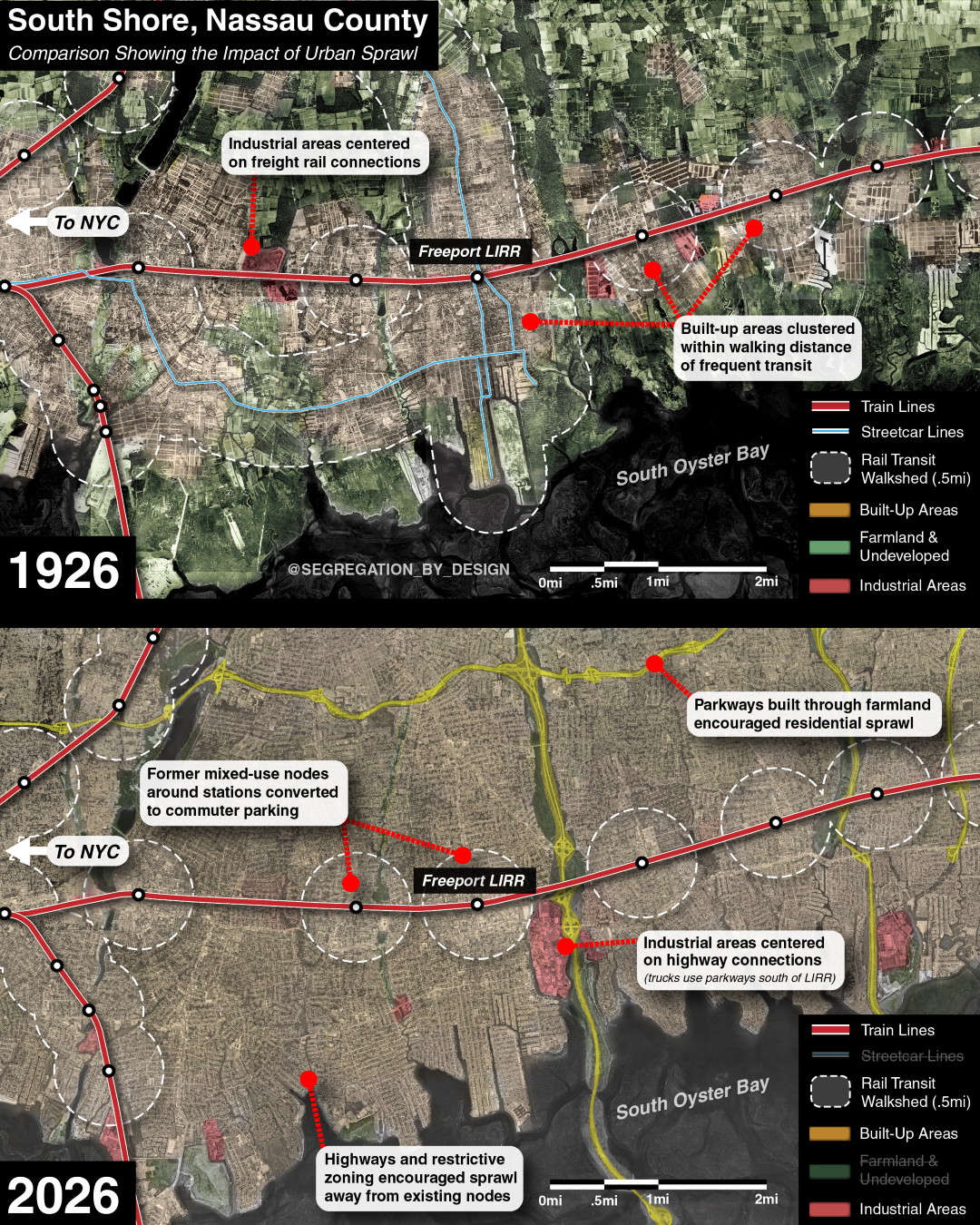
In short, the parkways and expressways turned the beach towns and farming communities of Long Island into the decentralized mass of residential suburban sprawl we know today. They fostered a disconnected, auto-centric development that drained the economic vitality of the existing mixed-use/rail-based nodes, while also ensuring that all future growth would be similarly single-use and car-based. Whereas the core of NYC was able to survive as a recognizably urban form despite RM’s projects (though of course not unscathed), the countryside was utterly transformed. Gone were small urban towns and farmland, as single-family development expanded like a gas from the parkways to fill every inch of undeveloped land in Nassau.
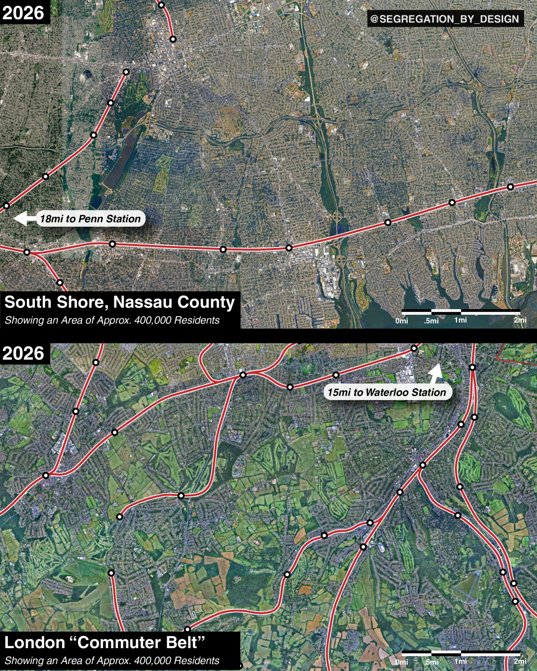
Compare this to the suburban development of what is arguably New York’s most similar peer city, London. Below, you can see images of suburban New York and suburban London at the same scale in a location containing roughly the same number of people, 400k. In New York, the area shown is about 18 miles from Penn Station; In London, it is about 15 miles from Waterloo Station. Both of these areas developed in the same era, beginning in the 1920s through the 1960s. Without single-family, restrictive zoning like New York’s, London’s development remained close to rail lines, further facilitated by UK “Green Belt” policies designed to protect farmland. Long Island had no such protection, and every available inch was developed. One can envision Long Island having taken a different path, similar to London, in which the island was simultaneously more urban, but had far more open space. And as in London, those wanting yards could still have had their pick. Front and back yards, certainly, sideyards perhaps not.
In any event, Moses claimed that the development of his highways, cutting through the city and into the undeveloped land of Long Island, was for the purpose of “alleviating congestion”--a goal which they plainly and immediately failed to achieve.
To wrap up (sort of), here’s Caro’s description of events:
In “The Power Broker,” Caro writes, “No crystal ball was needed to foretell the end result of Moses’ immense new highway construction proposal, coupled as it was with lack of any provision whatsoever for mass transit: it could not possibly accomplish its aim, the alleviation of congestion. It could only make congestion, already intolerable, progressively worse. His program was self-defeating. It was doomed to failure before it began. It just didn’t make sense.” [8]
“It made less sense still, planners felt, because of certain implications peculiar to the Moses-style of building,” Caro writes, most notably the blocking of additional transit provisions. Thus, “communities created by the opening of Moses’ Cross Island and Belt Parkways were characterized by larger lot sizes and lower population densities than those created by the opening of subways and railroads... As the open spaces of Nassau began to fill up and developers looked for fresh stretches of land to subdivide, they found themselves looking—and building new communities—much farther away from the center of the city than would have been the case if the impetus to such development had been not roads but railroads.” [9]
“The Coordinator’s proposed highways and garages were designed to help automobile-owning families,” Caro continues. “But in 1945 two out of three residents of New York City belonged to families that did not own automobiles. Many of these families did not own them because they could not afford to... The Coordinator’s grabbing of the lion’s share of public funds for highways and garages meant that public resources would be poured into a transportation system used only by people who could afford cars. Only a dribble of public resources would go into the transportation system used by people who could not—and who therefore rode subways and buses.” Moses' lack of investment in transit “was doing more than simply not helping these people. They were hurting them.” [10]
Caro writes that Moses' policies “were even limiting their freedom to choose a place to live,” referring to the vast majority of working class New Yorkers unable to afford a car in the 1940s. “Moses' denial of funds for the extension of mass transit into the outlying sections of the city and into the suburbs meant that new homes and apartments there would be occupied only by car-owning families... the ultimate effect of Moses’ transportation policies would be to help keep the city’s poor trapped... they were in effect policies not only of transportation but of ghettoization, policies with immense social implications.” [11]
“The answer to all the questions raised about Moses’ transportation policies was, of course, mass transportation. The problems of moving tens of thousands of commuters into and out of the center city—problems so unmanageable in terms of highway lanes whose peak capacity was 1,500 cars per hour—were reduced to manageable size by rapid transit lines, a single track of which could carry between 40,000 and 50,00 persons per hour,” Caro writes. [12]
“New highways had a vital function to fulfill: the transportation of people and goods that, for whatever reason, had no choice but to use the highways,” Caro writes. “If you had a viable mass transit system in the region—fast, clean, reasonably inexpensive, modern subways and suburban commuter railroads—you would attract to it a substantial share of the traffic that did have a choice, and by removing it from the highways, you would free the highways so that they would be able to fulfill this function. If residents of the region did not have a choice, if they were forced by the inefficiencies, inadequacies of service and high fares of mass transit whether they wanted to use them or not, the highways would never be able to fulfill their function. Build railroads at the same time that you were building roads, and solving the metropolitan transportation problem would be greatly simplified. Pour all available funds into roads without building railroads, and that problem would never be solved.” [13]
Referring to contemporaries (e.g. Lewis Mumford) who foresaw these issues, Caro writes “As for the Mumfords and other farseeing planners, Moses treated their predictions of disaster with the disdain he felt they deserved. Opponents who charged that he was unaware of the social implications of his transportation policies—that the ghettoization they caused, for example, was inadvertent—underestimated him. He knew precisely what he was doing. He had formed his own vision of Long Island long ago, and all he was doing now was holding true to it—and that vision did not include poor people.” [14]
ENDNOTES
Wiese, Andrew (2004). Places of Their Own: African American Suburbanization in the Twentieth Century. UChicago Press. Pp.94.
“What Makes Power Centers Bad for Cities” City Nerd (2022). https://www.youtube.com/watch?v=D2Pj6TcNP6Y (accessed 10/28/26).
Archer, Deborah (2020). “White Men’s Roads Through Black Men’s Homes: Advancing Racial Equity Through Highway Reconstruction.” Vanderbilt Law Review. 73-1259. Pp. 1290
Caro, Robert (1975). “The Power Broker: Robert Moses and the Fall of New York.” Knopf. Pp. 898.
“A Timeline of Land Use and Housing on Long Island.” Molloy University (2026). https://www.molloy.edu/about/community-outreach/history-of-long-island/land-use-and-housing (accessed 10/28/26).
Wiese, Andrew (2004). Pp. 100.
Wiese, Andrew (2004). Pp. 102.
Caro, Robert (1975). Pp. 898.
Caro, Robert (1975). Pp. 899.
Caro, Robert (1975). Pp. 900.
Caro, Robert (1975). Pp. 901.
Caro, Robert (1975). Pp. 902.
Caro, Robert (1975). Pp. 902.
Caro, Robert (1975). Pp. 908.