“It is increasingly clear to me that white flight was not a mystical process for which we have no real explanation or understanding. White flight was the policy of our federal, state, and local government. That policy held that Americans should enjoy easy access to the cities via the automobile and live in suburbs without black people, who by their very nature degraded property and humanity.”
-Ta-Nehisi Coates, @theatlantic
“If the ends don’t justify the means, what does?”-Robert Moses
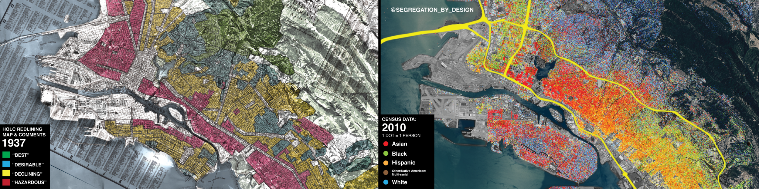
Using historic aerial photography, this ongoing project aims to document the destruction of communities of color due to red-lining, “urban renewal,” and freeway construction. Through a series of stark aerial before-and-after comparisons, figure-ground diagrams, and demographic data, this project will reveal the extent to which the American city was methodically hollowed out based on race. The project will cover the roughly 180 municipalities which received federal funding from the 1956 Federal Highway Act, which created the interstate highway system.
Since the creation of the Interstate, freeway planning has been an integral tool in the systematic, government-led segregation of American cities. Used not only as a direct means to destroy the communities in their paths, freeways have also been used to cement racial segregation and ensure its endurance. Working synergistically with the legacy of redlining, freeway planning became the ultimate enforcement mechanism: literal walls of concrete and smog that separated black communities from white. In the name of the thinly veiled racist policies of “urban renewal,” the freeways took the red lines off the map and built them in the physical world.

Rochester, NY, Freeway ROW and Redlining Map. Blue = “Slum Clearance”
Moreover, as the government used direct financial assistance to encourage suburbia to sprawl (suburbia closed to African Americans due to restrictive covenants), freeways provided the literal routes for “White Flight.” Of course these weren’t just routes to get white people to the suburbs, these were also walls to keep black and brown people trapped in the central cities. With remarkable consistency, across cities of varying population, geography, and history, the federal government hemmed in downtowns with orbital or near-orbital freeway routes that physically separated central cities from the suburbs. The effect of this has been to strangle the American city and its African-American residents in a physical, concrete “white noose.”
Through freeway construction and urban renewal, the government displaced hundreds of thousands of its own citizens while providing virtually no financial assistance to the internal refugees it had created. It obliterated entire communities, destroyed livelihoods, and robbed African-Americans of hard-earned equity in their cities. The generational effect of this has been to create a cycle of poverty, a feedback loop which prevents those in poverty from obtaining any equity in the city.
The people whose houses and business were destroyed, whose communities were wiped away, whose social networks were decimated: these people were assaulted and robbed by the government. They deserve direct reparation both financially and in terms of the built environment. This means first recognizing the freeway network as a physical symbol of white suprematism, radically rethinking it, and wholesale dismantling of much of it.

The dismantling of urban freeways would have the most benefit for those who have been directly victimized, constituting one means of reparations. But all Americans stand to gain. In its white suprematist zeal the government destroyed the lives of many, but it also destroyed the American city. In the middle of the 20th century, the government pursued a campaign against the American city with a similar intensity as it did against the German and Japanese city years before. Instead of bombs, the freeway and urban renewal were its weapons. To this day, many of our cities have not yet recovered. Freeways gash across cities in all directions, creating barriers of concrete and asthma-inducing smog. Shoddily built high-rise residential projects (set back from the street and with no commercial space) have replaced row-houses and brownstones. Surface parking has become a prevailing land use, replacing small shops and businesses.

Downtown Houston, 1982 (Photo by Alex MacLean (@landslides)
Our cities have become little more than towers poking up from beneath an ocean of parking. Once admired around the world, American urbanism has become a cautionary tale in the international community. It is nothing less than a national embarrassment, a symbol of the United States’ institutional prejudice and failure to adapt to the rapidly changing world.
Through historical photographs, this project will make salient not only those displaced directly in the paths of the freeways themselves, but also how these freeways have deliberately cemented an enduring segregation. I intend this project to be a sort of visual companion to such works as Richard Rothstein’s “Color of Law,” and Heather McGhee’s “The Sum of Us,” going city-by-city to see how the tactics of segregation played out on the ground.

The goal of this project is threefold:
Create an “Atlas of Urban Renewal” in book-form, revealing in concise photographic fashion the extent to which the government hollowed out roughly 180 downtowns and waged a racially-motivated “war against the center.” By revealing what was there before the freeway, people can begin to imagine what will be there after the freeway. In pursuit of this goal, I will use the funds from your donations to purchase higher quality aerial imagery suitable for digital and print. Currently the base historic aerial imagery is 1600x1600px at $10/image. With further funds from patreon I can buy the images at 3600x3600px for $30/image. Images this size will permit very high quality, large format printing on glossy stock.
Create digital materials for local groups opposing ongoing freeway expansion. As state governments continue to mindlessly widen freeways, community groups in cities across the country have formed in opposition. This project aims to support these groups by creating easily digestible graphics to spread awareness. To date (upon their request) I have provided material, including maps and diagrams, to groups opposing the expansion of I-45N in Houston, TX; the I-5 in Downey, CA; and the I-5 in Portland, OR. This material has been presented in public hearings as well as being featured on the influential urbanist site, Streetsblog.
Continue to grow the followership of Segregation by Design’s social media channels through regular posting, for the purpose of amplifying local voices in opposition to freeway expansion and raising further awareness.
Disclaimer
Segregation by Design is a personal project of Adam Paul Susaneck, an NYC-based architect. The views expressed on Segregation by Design are those of the Adam’s and the Adam’s alone.
List of Cities to be covered:
Alabama
Birmingham
Mobile
Montgomery
Alaska
Anchorage
Arizona
Phoenix
Tucson
Arkansas
Little Rock
California
Bakersfield
Fresno
Los Angeles County
San Diego
The Bay Area: SF, Oakland, SJ
The Inland Empire
Sacramento
Colorado
Denver
Pueblo
Colorado Springs
Connecticut
Bridgeport
Hartford
New Britain
New Haven
Stamford
Waterbury
Delaware
Wilmington
Washington, DC
Florida
Daytona Beach
Miami
Jacksonville
St. Petersburg
Tampa
Orlando
West Palm Beach
Georgia
Atlanta
Columbus
Macon
Savannah
Augusta
Hawaii
Honolulu
Idaho
Boise
Illinois
Chicago
Joliet
Aurora
Peoria
Rockford
Decatur
Indiana
Indianapolis
Gary
South Bend
Iowa
Des Moines
Council Bluffs
Sioux City
Kansas
Kansas City
Wichita
Topeka
Kentucky
Louisville
Lexington
Louisiana
New Orleans
Baton Rouge
Shreveport
Maine
Portland
Maryland
Annapolis
Baltimore
Massachusetts
Boston
Springfield
Worcester
Michigan
Detroit
Flint
Grand Rapids
Lansing
Pontiac
Muskegon
Kalamazoo
Saginaw
Minnesota
Minneapolis
Duluth
Saint Paul
Rochester
Mississippi
Jackson
Biloxi
Missouri
Saint Louis
Kansas City
Nebraska
Omaha
Lincoln
Nevada
Reno
La Vegas
New Hampshire
Manchester
New Jersey
Hudson County
Trenton
Newark
Camden
Atlantic City
Bergen County
Union County
Essex County
New Mexico
Albuquerque
New York
Poughkeepsie
Albany
Newburgh
Troy
Schenectady
Utica
Rochester
Niagara Falls
Buffalo
Syracuse
B. of Manhattan
B. of Brooklyn
B. of The Bronx
B. of Queens
B. of Staten Island
North Carolina
Charlotte
Winston-Salem
Durham
Greensboro
Raleigh
Asheville
Ohio
Akron
Cleveland
Toledo
Cincinnati
Youngstown
Dayton
Springfield
Hamilton
Oklahoma
Tulsa
Oklahoma City
Oregon
Portland
Eugene
Springfield
Pennsylvania
Philadelphia
Bethlehem
Scranton
Wilkes-Barre
Pittsburgh
Johnstown
Harrisburg
Puerto Rico
San Juan
Rhode Island
Providence
South Carolina
Columbia
Charleston
Spartanburg
Tennessee
Memphis
Knoxville
Nashville
Chattanooga
Murfreesboro
Texas
Laredo
Lubbock
Dallas
Amarillo
Fort Worth
Waco
Austin
El Paso
Galveston
Houston
San Antonio
Utah
Salt Lake City
Ogden
Virginia
Richmond
Roanoke
Lynchburg
Newport News
Norfolk
Washington
Seattle
Spokane
Tacoma
West Virginia
Wheeling
Charleston
Wisconsin
Milwaukee
Madison
Oshkosh