
DALLAS: Waiting for a Streetcar
Posted August 7, 2026
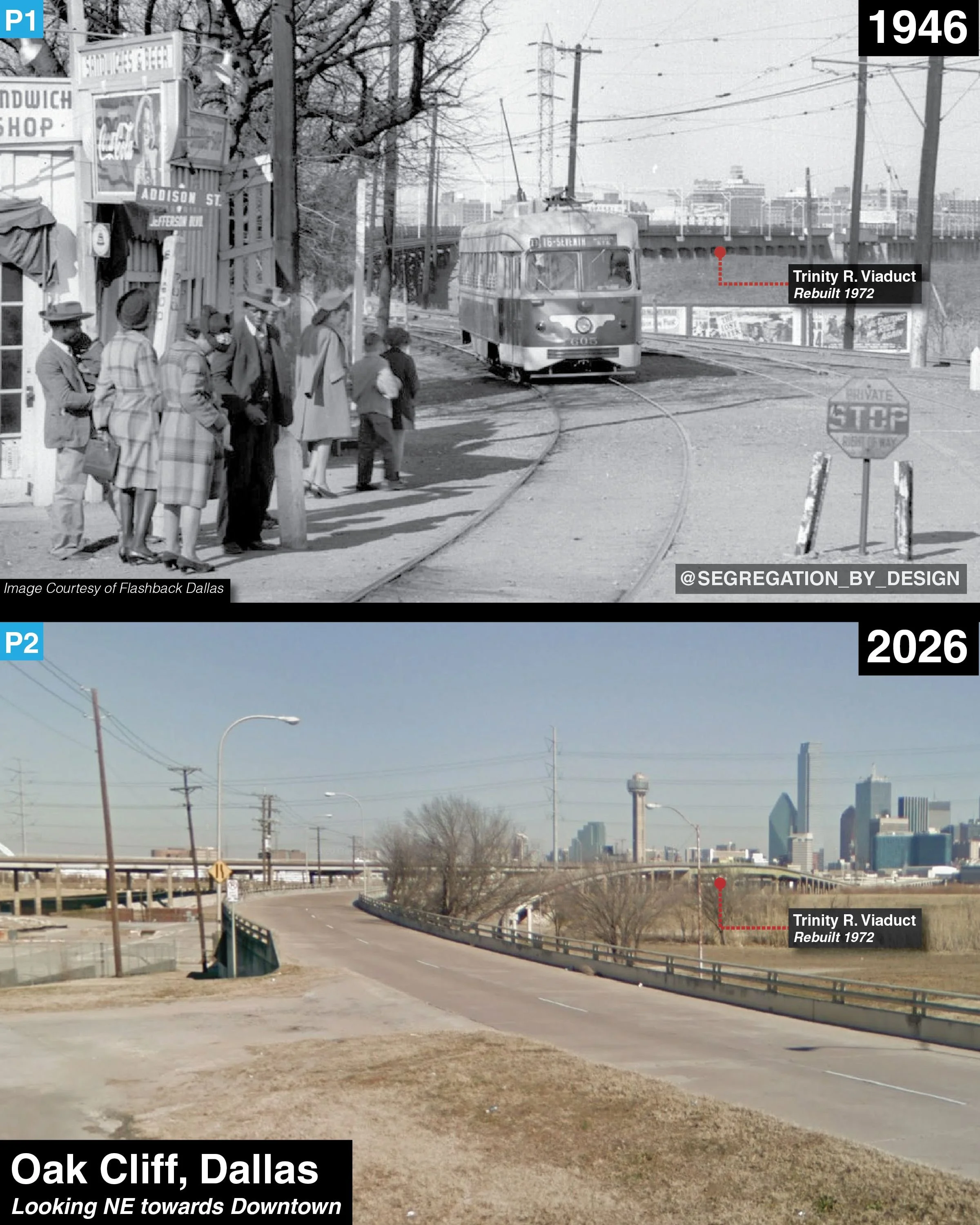
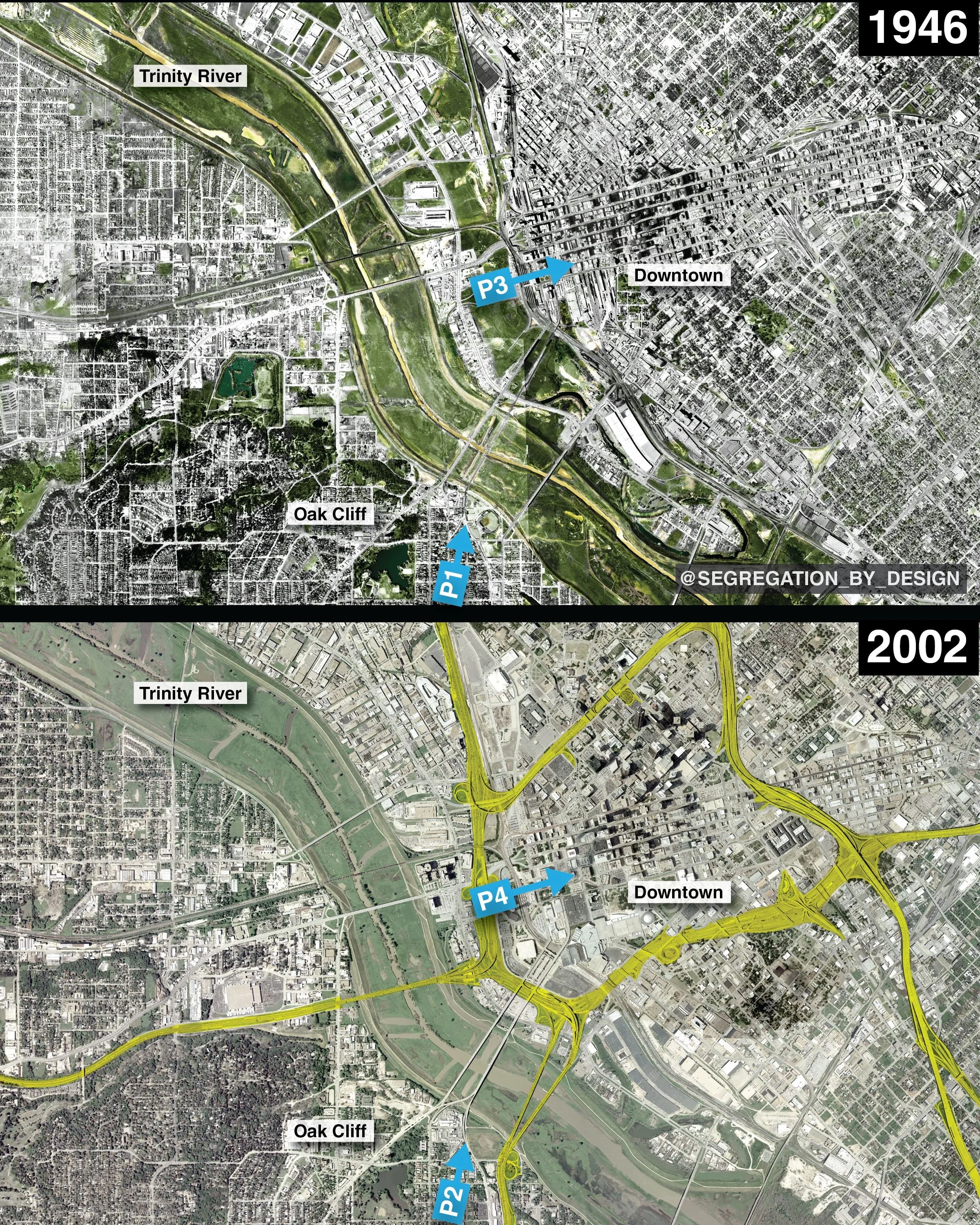
Oak Cliff, Dallas, 1946 vs. 2026. Taken at the corner of Addison St./Jefferson Blvd, the photo shows a crowd of people, Black and white, waiting for a streetcar as it exits the viaduct from across the Trinity River to Downtown [1]. Paula Bosse of the Dallas Public Library writes insightfully of the photo: “what was once such a commonplace scene—people waiting for a streetcar or interurban—now seems completely out of the ordinary and quaintly nostalgic. Nostalgic on its surface anyway—not shown is the interior of the car which had specific black-only and white-only seating for passengers.”[2]
This photo was taken on the cusp of postwar white flight and suburbanization which would radically transform the demographic geography of American cities over the ensuing decades [3]. Of course, prior to racialized suburbanization, American cities were also highly segregated, but that segregation took place within a pre-automobile urban form that necessitated the close physical proximity seen in this picture [4][5]. Cities were segregated block-by-block, with different races and classes in close contact on the streets, some public spaces, and transit. Lacking physical distance within these spaces (such as this streetcar), social distance was strictly maintained through the aggression of the Jim Crow regime and other de facto and de jure means [6].
However, as the Civil Rights Movement fought Jim Crow in the 60s, the legal basis for existing racial lines fell away. Unable to enforce social barriers in existing spaces via legal segregation, planners turned to the physical boundaries which could be created through highways and sprawl. “The Interstate Highway Act presented many governors, mayors, and city planners with a means of fighting back,” Archer writes. “The physical boundaries they created would withstand the adoption and evolution of civil rights laws.” [7].
On the flipside, “The same people who devised and built the highway systems also underfunded existing infrastructure in the areas decimated by the highways,” including transit systems and other public services [8]. When municipal operation began 1956, Dallas finally eliminated remaining rail service.
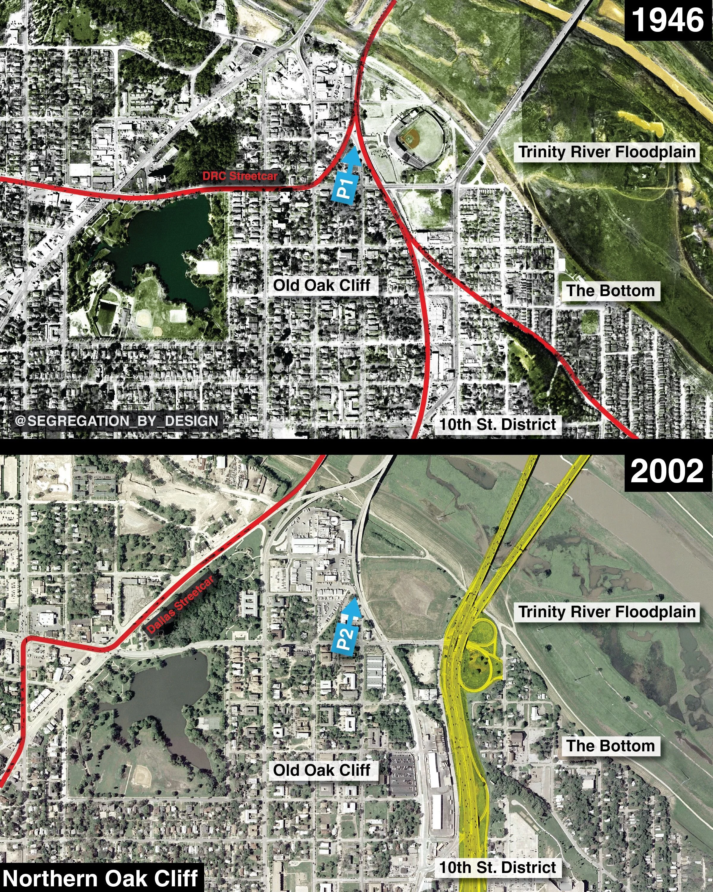
Especially interesting about the streetcar/interurban station seen here, this stop was right at the social boundary between Oak Cliff’s Black and white neighborhoods. Historically-Black Tenth Street Freedman’s Town was to the east of Jefferson Blvd (which intersected with nearby Davis St., lest anybody confuse to which “Jefferson” the name referred), and the rest of white Oak Cliff to the west. Because the streetcar was the primary means of transportation for all people, regardless of race, places like these necessarily strained the social divisions which Jim Crow intended to establish and uphold. After the legal color line was technically outlawed (with the ‘64 and ‘68 Civil Rights Acts), the prospect of integrated public spaces—transit, education, swimming pools—encouraged leaders to further divest from the public realm. [9]
As you can see in the maps below, the end of streetcar service isn’t the end of the story, as Dallas today boasts the longest light rail network by trackage in the US. After abandonment in ‘56, the city continued to operate bus lines under the municipally-owned Dallas Transit System (DTS), albeit at a diminished level of service from the earlier systems it had replaced. However, by the 90s, the thinking on rail had flipped: Dallas leaders had seen the success other cities had in boosting Downtown redevelopment through the construction of new rail networks. City Hall hoped to emulate their success, “revitalizing” Downtown Dallas, ravaged by years of population and job loss due to suburbanization (and exacerbated in the 90s by the Savings and Loan crisis)(see previous Dallas post for more info)[10].
Dallas Area Rapid Transit (DART), a new regional entity created in 1983 to replace the DTS, was particularly interested in the new “light rail” (LRT) systems being built in the 80s and 90s, which combined elements of traditional streetcars and suburban rail in a far cheaper package than a full-scale metro system.
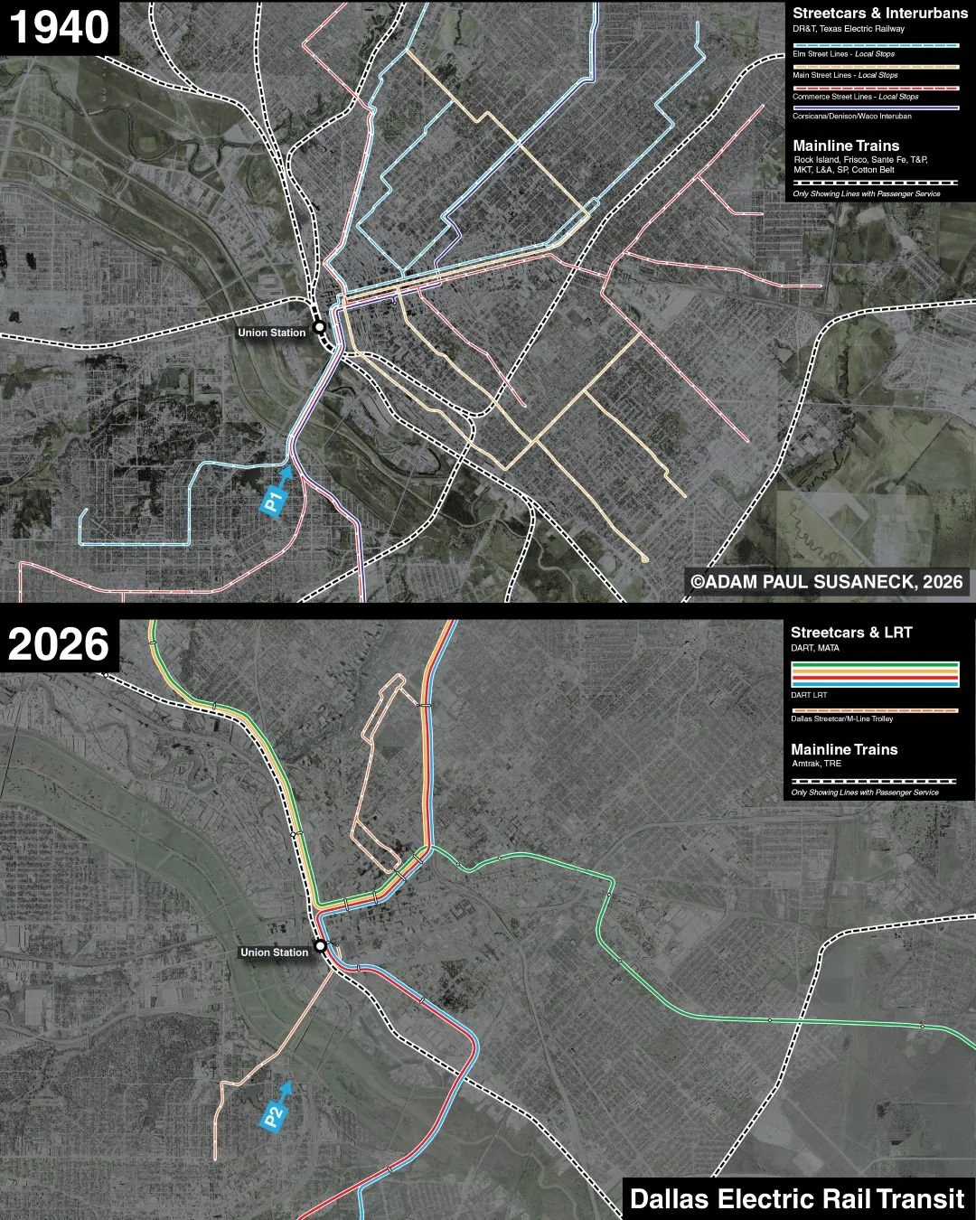
These “second generation” LRT systems featured highly radial routes which converged on Downtown, connecting to far flung park-and-ride stations in suburban areas. These systems had been designed to “revitalize” urban cores (read: gentrify, though it’s not quite as simple as that), rather than to reconnect the “inner city” neighborhoods formerly accessible by the streetcar network (and now divided by the highways and served by an underfunded bus network). To reduce the complexity and the cost to acquire land, these systems often used existing freight rights of way, or ran adjacent to highways, such as systems in San Diego (1981), Portland (1986), and Los Angeles (1990).
Dallas would follow a similar model, acquiring an impressive 125 miles of freight railroad ROW beginning in the 80s, and opening the first lines of the DART network on these tracks in 1996 [11]. The result of using these cheaper ROWs is that DART stations are generally poorly placed, missing key population and job centers. “Thus, it is not surprising that while DART’s 93-mile light-rail system is the longest in the country, it doesn’t make the top five in ridership,” writes Spieler. “Dallas has the most impressive rail system in Texas, but Houston, San Antonio, Austin, and El Paso all have higher per-capita transit ridership.” [12]
This outcome is even less surprising given the system’s focus on creating development opportunities and boosting real estate values, rather than necessarily providing effective transit service. Kimble writes, “for decades, DART had been fixated on rail. Developers loved it; fixed rail lines increased adjacent property values. And real estate development bolstered the property tax base, which cities loved.” [13] Over the years, poor ridership (and continuing racial animosity) has made it easier for Dallas suburbs to justify their periodic attempts to leave the DART regional entity, to replace it with their own transit service (as Highland Park did earlier this year with their “microtransit” service)[14], or eliminate public transit altogether (such as Arlington).
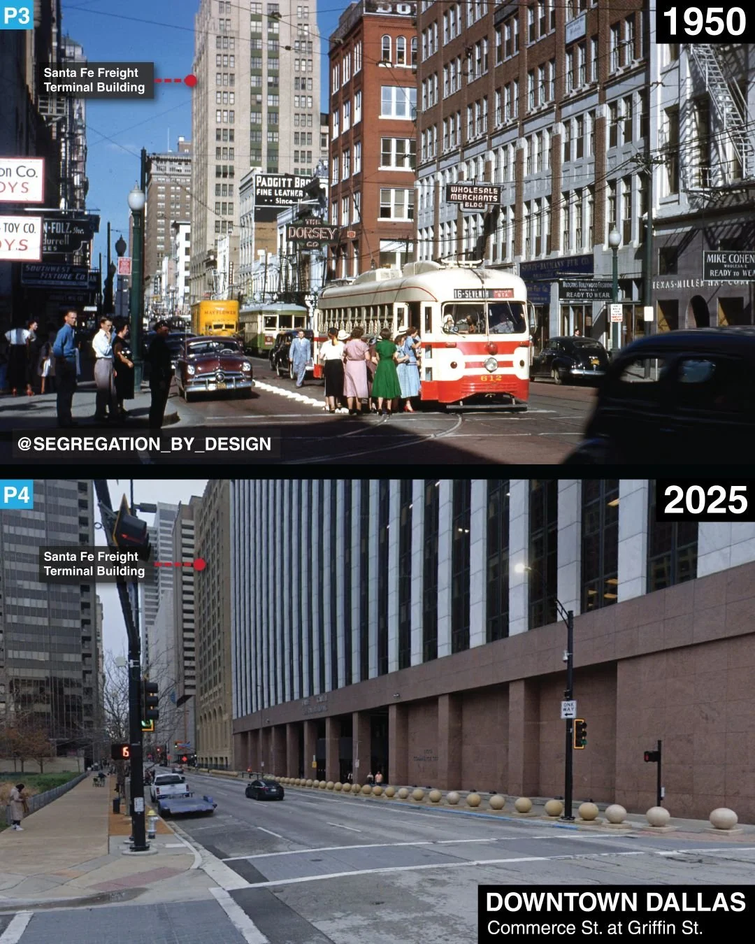
In any event, despite DART’s shortcomings, “the answer to the question of how to get people where they are going without a highway to take them there is in a bus or on a train” [15]. With thoughtful planning, affordable densification around stations, and a significant investment in the bus network, Dallas can make progress. I highly recommend checking out Megan Kimble’s “City Limits: Infrastructure, Inequality, and the Future of America’s Highway” for more on the recent transit situation in Dallas.
ENDNOTES
1. Bosse, Paula (2014). “Waiting for a Streetcar on a Sunny Winter Day in Oak Cliff, 1946.” Flashback Dallas. https://flashbackdallas.com/2014/10/30/waiting-for-a-streetcar-1946/ (accessed 8/7/26).
2. Bosse, Paula (2014).
3. Jackson, Kenneth (1985). Crabgrass Frontier: The Suburbanization of the United States. Oxford: Oxford University Press. Pp 14.
4. Harvey, David (2012). Rebel Cities: From the Right to the City to the Urban Revolution. London: Verso. Pp 9.
5. Norton, Peter (2011). Fighting Traffic: The Dawn of the Motor Age in the American City. Boston: MIT Press.
6. Rothstein, Richard (2017). The Color of Law: A Forgotten History of How Our Government Segregated America. New York City: Liveright.
7. Archer, Deborah N. (2025). Dividing Lines: How Transportation Infrastructure Reinforces Racial Inequality. New York: W.W. Norton & Company. Pp 29.
8. Archer, Deborah N. (2025).
9. McGhee, Heather (2021). The Sum of Us: What Racism Costs Everyone and How We Can Prosper Together. Profile Books.
10. “Dallas.” Segregation by Design.
11. Spieler, Christoph (2018). Trains, Buses, People: An Opinionated Atlas of US Transit. Island Press. Pp 101.
12. Spieler, Christoph (2018).
13. Kimble, Megan (2024). City Limits: Infrastructure, Inequality, and the Future of America’s Highways. New York: Crown. Pp 180.
14. Fechter, Joshua (2026). “Dallas’ Highland Park Votes to Leave Texas’ Second-Largest Public Transit System.” Texas Tribune. https://www.texastribune.org/2026/05/03/texas-dallas-dart-election-addison-highland-university-park/ (accessed 8/7/26).
15. Kimble, Megan (2024). Pp 178.